
A research team led by Prof. LIU Liangyun from the Aerospace Information Research Institute of the Chinese Academy of Sciences (AIRCAS) has produced the first comprehensive, high-resolution map of global city and town boundaries, offering a view of how urban boundaries have expanded and transformed over the past two decades. The new dataset—derived from 30-meter-resolution satellite observations—fills a long-standing gap in global urban studies.
Cities and towns are the dominant form of human settlement, playing a crucial role in sustaining ecological balance and advancing sustainable development. However, their complex spatial structures and rapid evolution have made high-resolution global urban boundary datasets scarce. To address this gap, the team integrated the GISD30 global impervious surface dynamic dataset with LandScan global population data to develop the Global City and Town Boundaries (GCTB) Dataset, which covers the period from 2000 to 2022.
Published in Scientific Data, the study details the researchers' development of a morphology-oriented boundary delineation framework that combines kernel density estimation (KDE) and cellular automata (CA) to accurately map urban boundaries. When compared with multiple reference datasets, the GCTB Dataset showed the strongest agreement with the manually curated Atlas of Urban Expansion, achieving an R2 value of approximately 0.88—indicating high reliability in capturing urban extents.
Independent validation using OpenStreetMap (OSM) place tags for three benchmark years (2015, 2020, and 2022) further confirmed the dataset's robustness. The GCTB Dataset achieved an average overall accuracy of around 0.75, with mean precisions of ~0.78 for cities and ~0.69 for towns—demonstrating consistent performance across both time periods and settlement types.
To showcase the dataset's utility, the researchers analyzed long-term urban changes in Beijing and Chicago using historical high-resolution Google Earth imagery. The results confirmed the accuracy of the GCTB Dataset in capturing the spatial evolution of city and town boundaries. Specifically, the dataset effectively traced the contrasting urban expansion patterns of the two metropolitan areas: capturing Beijing's rapid outward expansion and Chicago's shift toward a more stable urban structure between 2000, 2010, and 2020.
The full dataset is openly accessible on the Zenodo platform, providing detailed insights into the spatiotemporal evolution of cities and towns over the past 23 years. As cities worldwide continue to grow and reshape landscapes, the GCTB Dataset offers essential spatial evidence for monitoring urban expansion, guiding land-use planning, and advancing sustainable urban development.
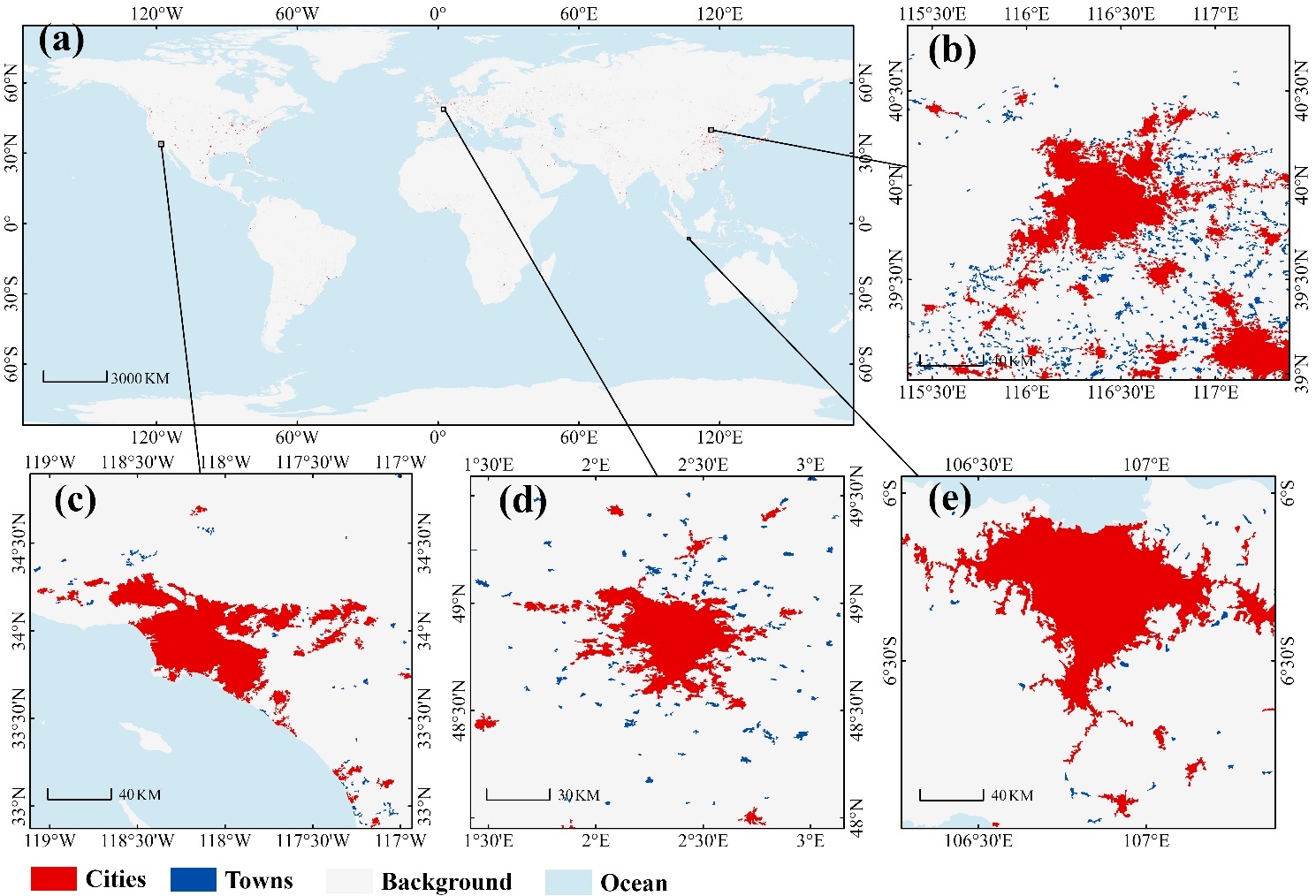
Global distribution of cities (red) and towns (blue) in 2022 at 30 m resolution (a), with insets for Beijing–Tianjin–Hebei (b), Los Angeles (c), Paris (d), and Jakarta (e). (Image by AIRCAS)

86-10-68597521 (day)
86-10-68597289 (night)

52 Sanlihe Rd., Xicheng District,
Beijing, China (100864)
Copyright © 2002 - Chinese Academy of Sciences


