
Newsroom


A research team led by Prof. SHI Chong from the Aerospace Information Research Institute (AIR) of the Chinese Academy of Sciences, in collaboration with Japanese scientists, has made a significant advancement in satellite-based air quality monitoring. They have developed AIRTrans, an innovative algorithm that greatly improves the accuracy and efficiency of retrieving key aerosol properties from multispectral satellite observations.
Aerosols—tiny particles suspended in the atmosphere—play a crucial role in air pollution, human health, and climate change. Two important indicators for studying aerosols are aerosol optical thickness (AOT), which measures the concentration of particles in the air, and the fine-mode fraction (FMF), which indicates the proportion of small particles, such as those from vehicle emissions or industrial processes.
Traditional satellite retrieval algorithms, which rely on pre-calculated lookup tables, typically utilize only two or three spectral channels. This limitation reduces the detail and accuracy of the results. Although full-physics optimal estimation methods offer more precision by leveraging additional spectral information, they are often too slow for real-time applications and can struggle with complex aerosol types.
To address these challenges, the researchers developed AIRTrans, a hybrid algorithm that combines physical modeling with machine learning techniques. The algorithm employs a radiative transfer model called RSTAR to simulate satellite spectral reflectance across diverse aerosol types and surface properties, creating an extensive database that pre-trains a neural network model. This model is then fine-tuned using ground-based measurements to enhance its accuracy and adaptability to various real-world scenarios. Additionally, AIRTrans accounts for hourly changes in surface reflectance and background AOT, further improving its precision.
AIRTrans is specifically designed for use with multispectral instruments like the Advanced Himawari Imager (AHI) onboard Himawari-8, which observes the East Asia region every 10 minutes. This capability allows for real-time, high-frequency tracking of aerosol changes throughout the day—something traditional methods struggle to achieve.
When tested against ground-based measurements, AIRTrans achieved a root mean square error of just 0.132 for AOT and 0.146 for FMF, representing significant improvements of about 40% and 49%, respectively, compared to the official Himawari-8/AHI products.
Notably, AIRTrans resolved the systematic underestimation of FMF seen in existing retrieval products. During real-world events such as dust storms and haze episodes, AIRTrans successfully captured the spatiotemporal dynamics of aerosol concentrations and particle sizes, underscoring its effectiveness for pollution monitoring and early warning purposes.
This study demonstrates that AIRTrans is not only accurate and fast but also widely applicable. It can be adapted for use with other multispectral satellite sensors, providing support for precise air pollution control and climate change efforts, particularly in the context of carbon neutrality goals.
The findings were published in Remote Sensing of Environment, and this study was supported by the National Natural Science Foundation of China.
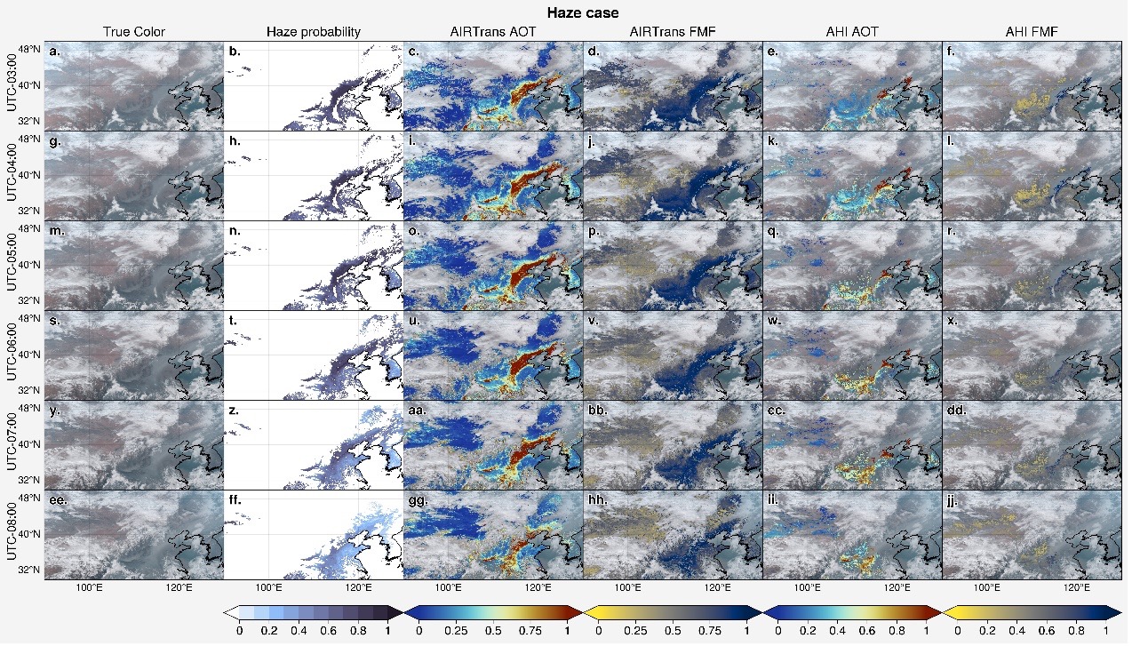
True-color images and haze probability maps depict a Feb 12, 2021 North China haze event. AIRTrans data show decreasing aerosol optical thickness (AOT) from 03:00–08:00 UTC, aligned with lower haze probability, while elevated fine-mode fraction (FMF) indicates anthropogenic aerosols. (Image by AIR)


