Newsroom


A research team, led by Prof. MENG Qingyan from the Aerospace Information Research Institute of the Chinese Academy of Sciences, has successfully developed the Global Spatiotemporal Fusion Model (GLOSTFM), a high-efficiency spatiotemporal fusion model that utilizes multi-source satellite data. By integrating thermal infrared and microwave observations from the Fengyun-3D (FY-3D) satellite, GLOSTFM enhances the spatiotemporal resolution of land surface temperature (LST) data. The findings were published in Remote Sensing of Environment.
LST is a crucial indicator for researching climate change, ecosystems, and human health. However, traditional remote sensing technologies often face challenges, such as limited spatiotemporal resolution from individual sensors and cloud cover interference, which can lead to data gaps or decreased accuracy.
To address these limitations, the researchers developed the GLOSTFM model, which combines the "image pyramid" principle with the multi-source satellite data. This technique layers high-resolution thermal infrared imagery (with a resolution of 1 km) onto low-resolution but all-weather microwave data. The model gradually merges these layers to produce a high spatiotemporal resolution global LST product. Utilizing the FY-3D's daily revisit capability, GLOSTFM incorporates microwave data to cover cloud-covered areas, significantly reducing data loss.
In this study, the researchers tested GLOSTFM in five representative global regions, including major cities like Beijing and Shanghai, as well as agricultural zones in Australia, yielding impressive results. The fused land surface temperature data generated by GLOSTFM demonstrates high accuracy, with temperature estimates averaging only 2.87 K off from real-world measurements. Additionally, the data shows a correlation coefficient (R²) of 0.98, closely aligning with actual observations, making it a reliable tool for climate and environmental research.
Moreover, GLOSTFM can process 648 million pixels of global data in 25 minutes, which is dozens of times faster than traditional models. This capability allows for the handling of large-scale data in near real-time for the first time.
By overcoming the trade-off between high resolution and extensive coverage in land surface temperature monitoring, this technology provides high-precision data that supports climate modeling and carbon neutrality initiatives.
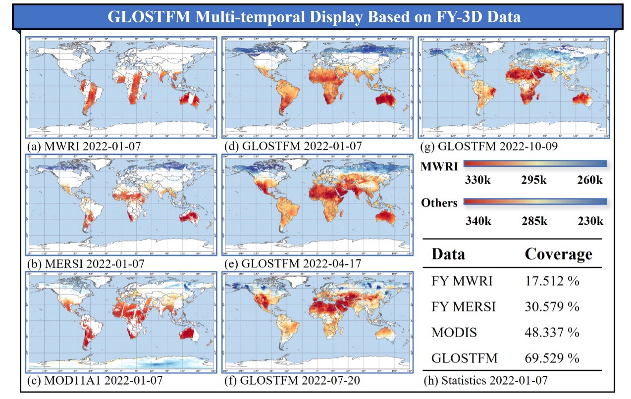
GLOSTFM multi-temporal display based on FY-3D data. (Image by AIR)