
Put ocean into a computer and explore it by a mouse---What we call “Digital Ocean” is changing our way of ocean exploration. Derived from the concept of “Digital Earth”, "Digital Ocean” is a virtual ocean world. It is also a complicated system engineering comprising massive, multi-resolution, multi-temporal and multi-type ocean observing data from space, ocean monitoring and observing data and related analysis models and arithmetic.
China “Digital Ocean” Program is shaped according to national ocean development strategy, aiming to explore and manage ocean from the perspective of sustainable development. It is designed to benefit China ocean administrations, professionals, and the general public. The development of this system involves multi-disciplines and collaborative efforts among ocean administration agencies, universities, enterprises and research institutes.
China Digital Ocean Prototype System (CDOPS), as the kernel part of China Digital Ocean Program, was designed and developed by the Institute of Remote Sensing Applications (IRSA) since 2007, and was completed in November, 2011.
It was constructed according to the data integration and application requirements of the State Oceanic Administration of China. The framework design of the CDOPS considers the characteristics of multiple distributed data resources, different application subjects, and different application modes.
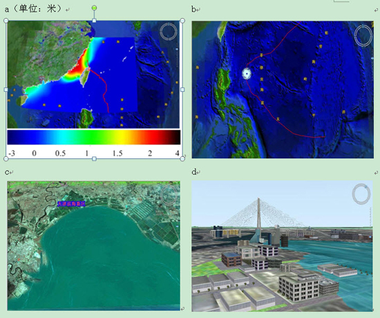
CDOPS is an information system which is based on ocean fundamental geographic data, ocean monitoring data and ocean business data and supported by an interactive and three dimensional visualization platform sphere, realize digital reappearance, forecast and prediction for ocean natural elements, phenomena and their change processes, such as sea bottom, water, sea surface, and islands and coastal zone. It involves technologies and methods such as wideband network, satellite remote sensing imagery data acquisition, mass data storage and compression, interoperability, scientific computing, distributed objects, and virtual reality, spatial data warehouse, metadata database and Web GIS etc.
Involving in China Digital Ocean fundamental information infrastructure (908-03), CDOPS serves as a proof-of-concept engineering program. It breaks through pivotal and prospective technologies, and establishes technology foundation for the digitization of ocean exploitation, management, decision, maintenance for rights and interests. As the first stage of China Digital Ocean, CDOPS will be evolved, evaluated, and expanded to real China Digital Ocean System (CDOS), which is the application case of “Digital Ocean”.

86-10-68597521 (day)
86-10-68597289 (night)

86-10-68511095 (day)
86-10-68512458 (night)

cas_en@cas.cn

52 Sanlihe Rd., Xicheng District,
Beijing, China (100864)
Copyright © 2002 - Chinese Academy of Sciences


