
Newsroom


A new study published in Nature Communications has found that 17.31% of tropical tree cover—an area spanning 395.9 million hectares (Mha)—has been consistently overlooked by global forest monitoring systems, exposing significant gaps in efforts to track deforestation and ecological degradation.
Using high-resolution satellite imagery (under five meters) and an advanced automated algorithm, an international research team mapped previously undetected tree cover (PUTC) across pan-tropical regions from 2015 to 2022. Their analysis revealed a net loss of 61.05 Mha in tropical tree cover during the period, with declines occurring not only in traditional forest areas (63.93%) but also in non-forested landscapes such as farmlands, grasslands, and urban zones (36.07%).
Regions with high concentrations of PUTC—where trees grow outside conventional forest boundaries—saw the most dramatic changes, highlighting limitations in widely used 10-meter resolution datasets like World Cover, the researchers noted.
The study, led by Prof. WANG Li from the Aerospace Information Research Institute (AIR) of the Chinese Academy of Sciences, documented a gross loss of 67.24 Mha (2.94% of total tropical tree cover) over the eight-year period, vastly outpacing gains of just 6.19 Mha. Brazil, Indonesia, and the Democratic Republic of Congo bore the brunt of these losses.
Human activities emerged as the primary driver of tree cover decline, accounting for 56.03% of losses—with logging, land conversion, and deforestation linked to 53.93% of total declines. Meanwhile, 43.98% of tree cover gains were attributed to increased rainfall.
"Neglecting scattered trees has led to a systematic underestimation of ecological degradation," said Dr. LIU Shidong, the lead author of the study. "Our maps show these trees play a critical role in buffering climate change and supporting local livelihoods. Their loss jeopardizes carbon storage and ecosystem resilience."
The findings raise concerns about the effectiveness of global climate and conservation commitments, including the Glasgow Declaration from COP26, where 141 nations pledged to halt deforestation by 2030. Current restoration initiatives, such as the Bonn Challenge, are also falling short: pan-tropical tree cover gains between 2015 and 2022 totaled just 6.19 Mha, far below global targets.
To conduct the analysis, the team developed a machine learning algorithm capable of automatically identifying tree crowns across diverse landscapes using five-meter resolution imagery from Planet satellites. Validated against 150,000 ground-truth points, the model achieved 97.31% accuracy—representing an advancement over existing monitoring methods.
"Fine-scale mapping is essential for credible climate mitigation," said Prof. WANG. "Policymakers must integrate non-forest trees into conservation strategies to combat degradation and biodiversity loss."
This research was a collaborative effort involving scientists from institutions including France's Climate and Environmental Sciences Laboratory, the University of Copenhagen, Spain's Global Ecology Unit (CREAF-CSIC-UAB), Humboldt University of Berlin, the University of Chittagong, Tsinghua University, and China University of Geosciences (Beijing).
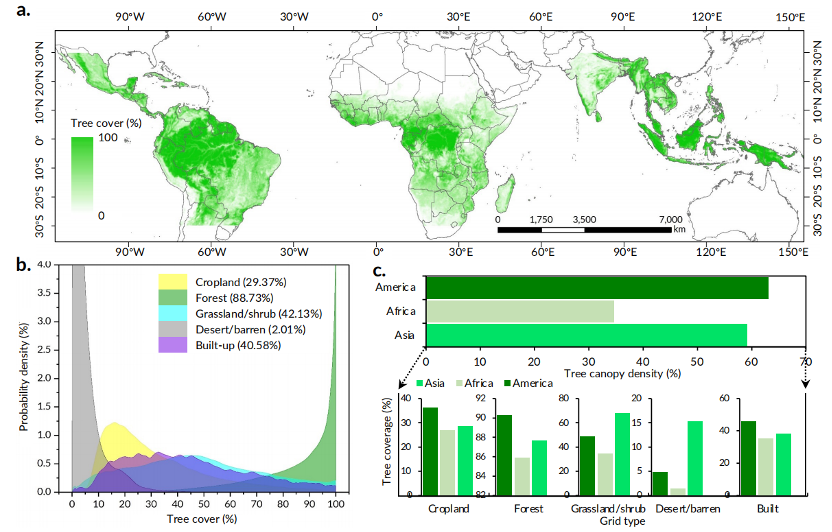
Pan-tropical high-resolution tree cover map. (Image by AIR)
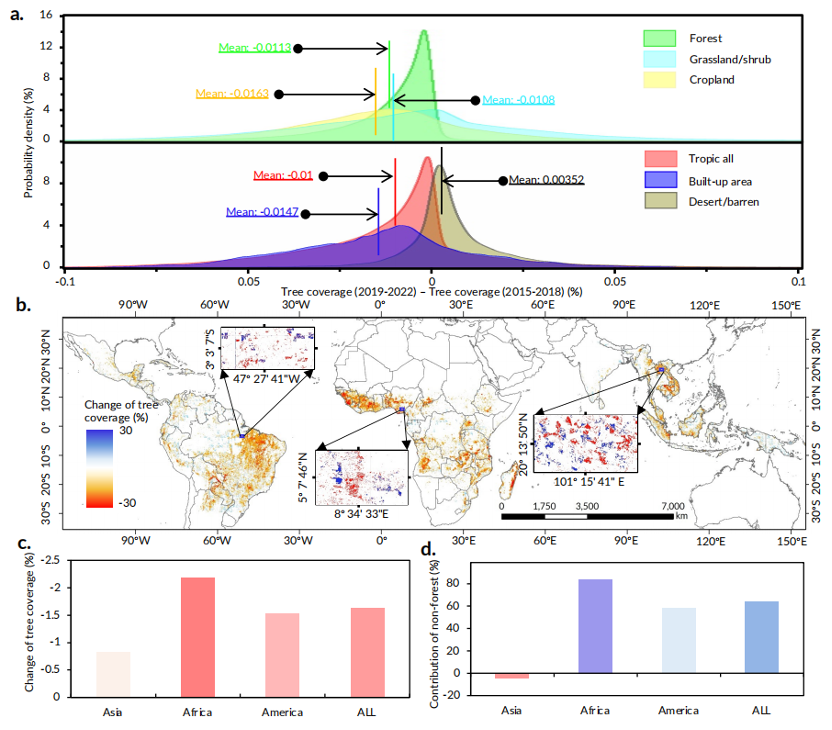
Pan-tropical high-resolution tree cover change map. (Image by AIR)

