
Newsroom


A global sea state dataset based on the ENVISAT/ASAR wave mode data recently has been released by scientists from the Aerospace Information Research Institute (AIR) of the Chinese Academy of Sciences (CAS).
The dataset derived from decadal spaceborne Synthetic Aperture Radar (SAR) data is the first of this kind that describes global sea state in terms of ocean wave integral parameters of significant wave height and mean wave period.
The spaceborne SAR has exhibited unique advantages and great potentials in ocean observations due to its capabilities of operating independently on sunlight and weather conditions, and imaging with high spatial resolution. The ERS-1/2 SAR, ENVISAT/ASAR and Sentinel-1 operated by European Space Agency (ESA) and the GaoFen-3 by China all can acquire data by the so-called "wave mode", which is an unique imaging mode of SAR designed for global ocean wave observations.
Based on more than 6,400,000 scenes of the wave mode data acquired during the lifetime of ENVISAT/ASAR satellite (from August 2002 to April 2012), Dr. LI Xiaoming and Ph.D. candidate HUANG Bingqing from AIR developed this global sea state dataset. The dataset breaks through the dependency on the priori information (mainly provided by the numerical wave modeling) in the SAR-ocean wave conventional retrieval approaches.
It also makes a great step on yielding the full sea state (both windsea and swell) of ocean waves, while only ocean swell information is available in the standard ASAR wave mode level 2 products. Apart from advanced algorithm being used to produce the dataset, the scientists also conducted detailed validation, calibration and quality control to ensure high quality of the dataset.
It is hoped that the dataset contribute to various studies related with ocean waves in the global oceans, e.g., protection of marine environment, wave climate change, utilization of renewable ocean wave energy, as well as shipping safety.
The research is partly supported by the National Key R&D Program of China and the CAS Strategic Pioneer R&D Program "Big Earth Data Science Engineer Project (CASEarth)".
Dataset and Description Downloading(1) The CASEarth data sharing and service system
Link: http://data.casearth.cn/sdo/detail/5e215848329b560ea47e783e
(2) The French scientific data center of marine science (SEANOE)
Link: https://www.seanoe.org/data/00601/71337/
A pre-print "Data Descriptor" which detailedly describes the processing methods, quality control and data formats of the dataset is also available for downloading via: https://www.preprints.org/manuscript/202001.0200/v1.
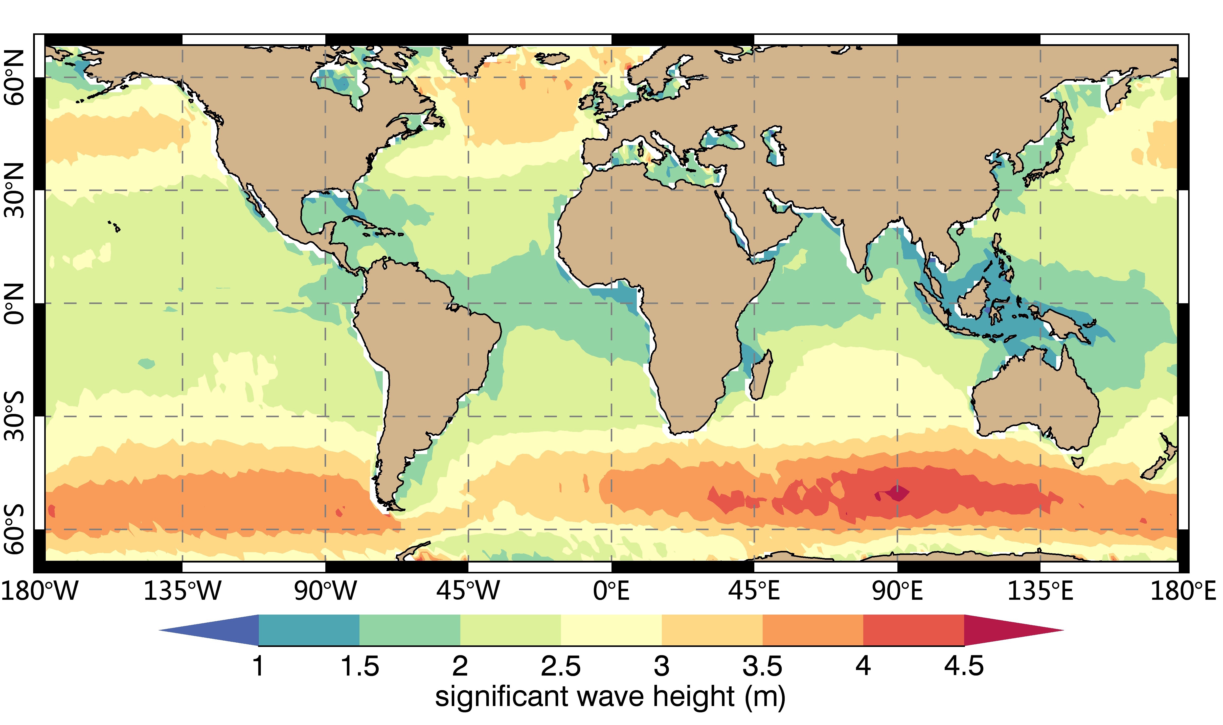
The map of mean significant wave height of the global ocean based on the developed dataset. (Image by AIR)

