Newsroom


A research team from the Aerospace Information Research Institute of the Chinese Academy of Sciences (AIRCAS), in collaboration with the International Research Center of Big Data for Sustainable Development Goals and the University of Chinese Academy of Sciences, has revealed that the Surface Water and Ocean Topography (SWOT) satellite can track changes in lake volumes across China with high accuracy, providing improved monitoring of small lakes that were frequently missed by earlier methods.
By combining simultaneous measurements of lake level and area with supporting bathymetric data, the team identified distinct seasonal patterns and an overall increase in lake volume, driven primarily by natural and larger lakes.
Their findings were recently published in Journal of Remote Sensing.
Lake volume is a key indicator of water security, ecosystem health, flood management, and climate response. However, traditional field measurements are sparse—particularly in remote regions—and earlier satellite approaches often struggled to measure lake level and area simultaneously. Small lakes have been especially difficult to monitor due to limited spatial resolution, cloud interference, and mismatched observation timings across sensors. These gaps have hindered the development of reliable, large-scale records of inland water changes.
To address these challenges, the team evaluated whether officially released SWOT lake products could overcome long-standing challenges in tracking inland water storage, particularly for small lakes and regions with incomplete conventional observations.
They found that SWOT significantly enhances the monitoring of China's lakes—especially smaller ones—generating volume estimates with high reliability. Validation against in situ reservoir records showed that most errors were within 10%, with the best-case scenario reaching just 3.92%.
Using their established workflow, the team produced lake-volume estimates for 1,596 lakes: 1,556 derived directly from SWOT observations and 40 supplemented with external bathymetric data. Statistically significant volume trends were identified in 583 lakes, revealing an overall increase of 0.7754 gigatons (Gt) per month. Approximately 85% of this change stemmed from natural lakes, with large and super-large lakes contributing the most to the increase.
To build the dataset, the team analyzed SWOT's Level 2 Lake Single-Pass Vector Data Product records from April 2023 to December 2024 for lakes larger than 0.0625 km2 in China. They filtered low-quality observations, removed outliers, and matched lake-level and lake-area measurements to construct hypsometric models that convert water-surface changes into volume changes. Depending on the lake, they applied constant-area, linear, quadratic, or cubic models and integrated external bathymetric datasets where SWOT alone could not fully cover larger lakes. In validation tests, lake-level-based estimates outperformed area-based ones, demonstrating lower errors and greater stability.
The results also revealed strong regional seasonality: Lakes in eastern China generally rise from winter to summer and decline from summer to autumn, while ice cover created winter monitoring gaps in plateau and northern regions. Even so, SWOT maintained a high observation frequency for small lakes and broad spatial coverage across China's five major lake regions.
The researchers noted that SWOT could become an essential tool for basin-scale water accounting, drought and flood assessment, reservoir management, and climate-change research.
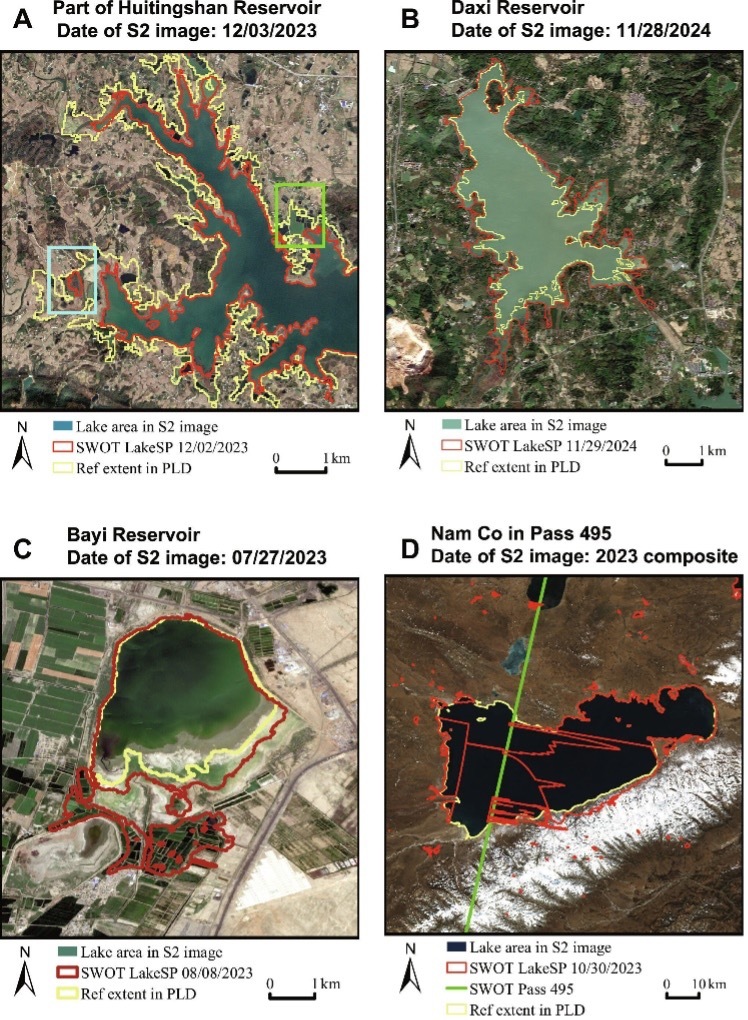
Lake extent derived from SWOT L2 HR LakeSP data compared to Sentinel-2 optical images in case lakes. (Image by AIRCAS)