
Recently, researcher JIANG Liming from the Institute of Geodesy and Geophysics (IGG) ,Chinese Academy of Sciences, cooperated with Professor ZHAO Yong from the China Institute of Water Resources and Hydropower Research made significant progress in the investigation of deep groundwater reserves in North China Plain using Interferometric Synthetic Aperture Radar (InSAR) technology.
Their study entitled "Combining InSAR and hydraulic head measurements to estimate aquifer parameters and storage variations of confined aquifer-system in Cangzhou, North China Plain" was published in Water Resources Research.
Since the 1970s, the groundwater overexploitations in shallow aquifers (unconfined aquifers) and deep aquifers (confined aquifers) has resulted in large-scale groundwater storage (GWS) depletion, groundwater pollution, seawater intrusion, and aquifer system compaction/land subsidence in the North China Plain. Therefore, it is necessary to monitor GWS variations and investigate the spatiotemporal patterns of aquifer system response to groundwater changes.
Although some progress has been made in the use of InSAR to observe the inversion of aquifer parameters, these methods require a large number of aquifer parameters to be constrained, and it is difficult to apply in the North China Plain.
Aiming at the above problems, the researchers presented a method to quantify aquifer parameters and GWS variations in the confined aquifer system in central Cangzhou by synergistically using InSAR and hydraulic head measurements.
The advantage of this method is that it can obtain water release coefficient of the confined aquifer skeleton with high spatial resolution, and it does not need prior knowledge such as the preconsolidation head, which can effectively separate inelastic compaction/subsidence and its corresponding irreversible GWS (IGWS) loss in this region.
The investigation revealed that there were multiple sedimentation funnels in the Cangzhou area from 2003 to 2010 (maximum sedimentation rate of 7.4 cm/yr), but some areas had significant uplift (maximum uplift rate of about 2.5 cm/yr) (Fig. 1(a)). And the seasonal deformation lags the head change up to 175 days (Fig. 2).
In addition, the deep GWS in central Cangzhou has a significant loss trend (Fig. 1b), and the annual loss rate is about 8.20±2.36×10⁷ m3, most of which is weakly permeable laminated dense water (Fig. 1d), which means the groundwater are seriously overexploitations, and even some areas of the aquifer are drained during this period.
It is worth noting that since 2005, the Cangzhou government has gradually controlled deep groundwater exploitation and increased surface water supply. The water level in some areas has increased year by year, and the rate of loss of weakly permeable laminated water has slowed down (Fig. 3), indicating groundwater pressure in the region. These measures have a certain slowing effect on deep groundwater overexploitations.
The research not only fills in the gaps in the study of groundwater weakly permeable laminated water in the North China Plain, but also provides a new means for quantitatively detecting the dynamic changes of GWS reserves in the North China Plain.
The study was supported by the National Natural Science Foundation of China, the National Key R&D Program of China, and the Key Research Program of Frontier Sciences, CAS.
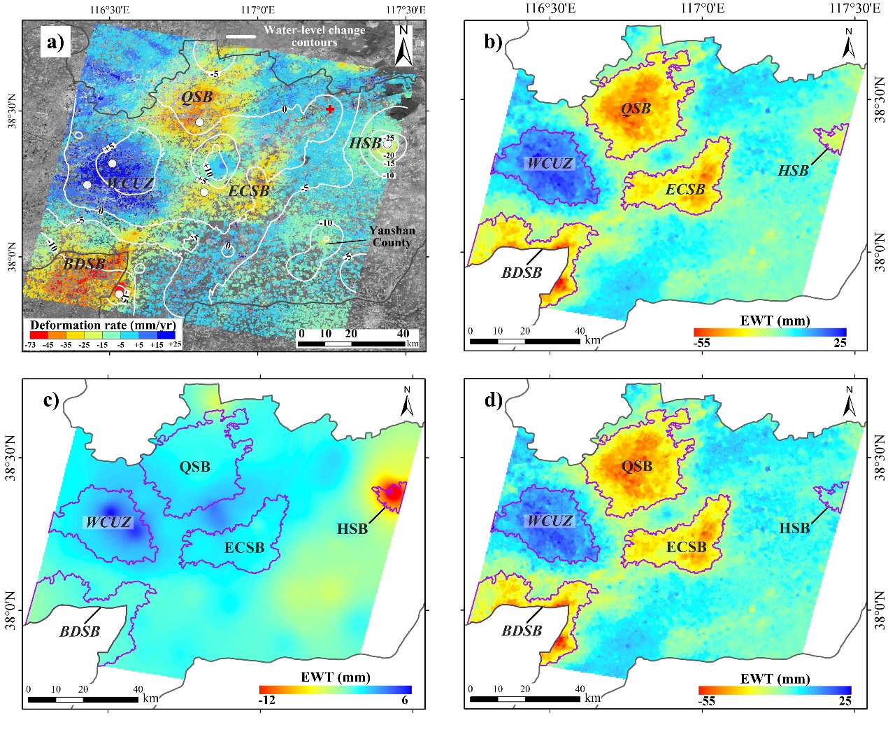
Fig.1 (a)Annual average deformation rate of central Cangzhou from 2004 to 2010; (b) deep groundwater reserve loss; (c) recoverable aquifer elastic release; (d) unrecoverable weakly permeable laminated dense release water. The purple solid line is the demarcated deep groundwater loss area and recovery area. (Image by IGG)

Fig. 2 Correlation analysis of seasonal head and deformation time series of typical well locations. Surface deformation lag head change from 0 to 175 days. (Image by IGG)
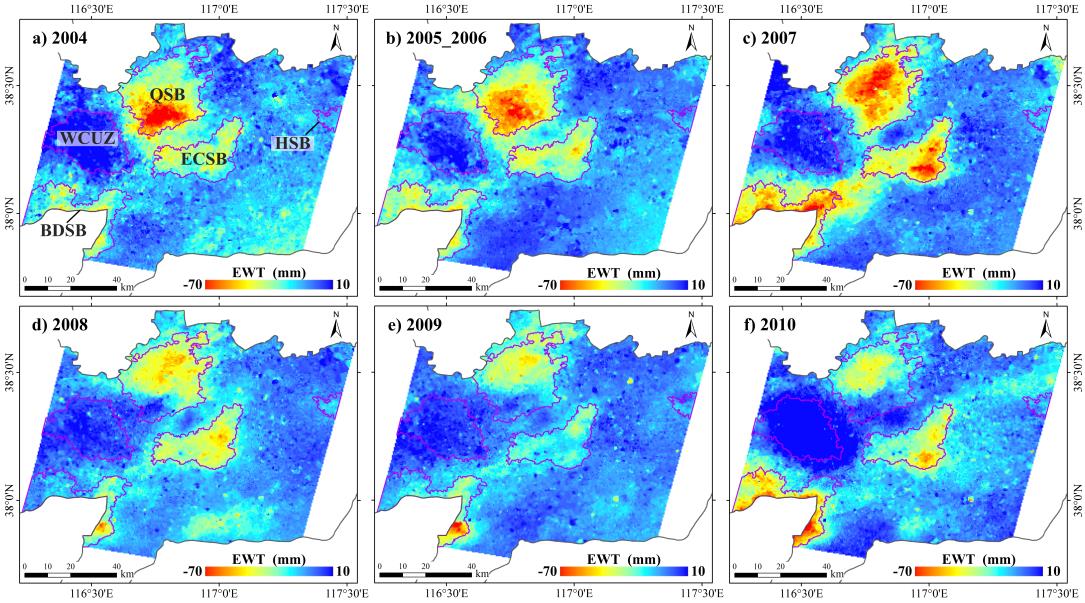
Fig. 3 The high spatial distribution of the equivalent water column for the annual irreversible water reserve loss in central Cangzhou from 2004 to 2010. 2005_2006 represents the average of irreversible groundwater storage losses in 2005 and 2006. (Image by IGG)

86-10-68597521 (day)
86-10-68597289 (night)

86-10-68511095 (day)
86-10-68512458 (night)

cas_en@cas.cn

52 Sanlihe Rd., Xicheng District,
Beijing, China (100864)
Copyright © 2002 - Chinese Academy of Sciences


