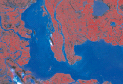
Satellite images of the Dongting lake in China during the 1998 summer flood.
Facing a forthcoming flood, what actions should decision-makers take first: evacuation of the population, reinforcement of dykes or intentional breaking of dikes? A support decision system recently developed by an international team of researchers will better facilitate them to make most appropriate decisions to limit flood damages.
From early 2000 to late 2002, CAS researchers from the Institute of Automation, the Institute of Remote Sensing Applications and the Institute of Atmospheric Physics teamed up with their Chinese and European colleagues in conducting a three-year project on an information system for flood prevention. The project was jointly supported by the European Commission, the Chinese Ministry of Science and Technology and the World Bank.
Entitled Data Fusion for Flood Analysis and Decision Support (ANFAS), the project has so far developed, by integrating the state-of-the-art techniques in data processing and management, a simulation and prevention tool to help decision-makers in taking decisions to reduce flood damage.
The Sino-European partners bring together a pool of expertise in remote sensing, scientific computing, computer vision, internet technology, geographic information systems, knowledge-based systems, soil sciences, and other areas.
According to experts, the final product is a decision support system (DDS) with near real time prediction capabilities. It is a multi-disciplinary approach that combines established techniques, know-how and knowledge from different fields in order to create as far as possible a complete model for describing the flood plain, flood analysis and simulation.
The system uses data from the most advanced acquisition technologies. In particular, remote sensing imagery - optical radar, interferometry radar - is incorporated in a conventional Geographical Information System database in the system to perform flood simulation, simulating water flow propagation based on scenarios.
With the support from Infodev Program of the World Bank, pilot applications of the system has been carried out on the Vah River in Slovakia, the Loire in France and the Jingjiang reach on the Yangtze River in China. The Vah site has been used to develop and create the system; the Loire and the Yangtze River for validation. The project has focused on the applications of the DSS in China, in particularly on the Jingjiang sector on the Yangtze River


