Newsroom


Chang’e-5 (CE-5) is scheduled to be launched by the end of 2020, which is the only lunar sample-return mission since Apollo 17. The planned landing area is near Mons Rümker in Oceanus Procellarum.
A research team from the Aerospace Information Research Institute (AIR) of the Chinese Academy of Sciences has made a precise lunar crater map within the planned landing area of CE-5, as well as a surface age analysis of the craters. The study was published in Earth and Planetary Science Letters.
Craters are the most prominent landforms in lunar surface, and they can provide important information on the topographic and geologic evolution of the study area. Most importantly, they can be used to refine the current lunar chronology function combing with radioisotope dating of the returned sample by CE-5.
To accurately map the craters as many as possible, a digital orthophoto map (DOM) with high resolution is necessary. Currently, the Narrow Angle Camera (NAC) onboard Lunar Reconnaissance Orbiter (LRO) obtains the highest resolution lunar orbital images, with the pixel size ranging from 0.5 m to 2.5 m at different flight altitudes.
765 NAC images with high quality and similar solar elevation were deliberately selected from more than 2000 images in this area. This data, along with a DEM product of SLDEM2015, was used to generate the base map for mapping craters. The derived base map covered an area of 413.8 km × 121.4 km with 224721 × 44945 pixels, with a pixel size of 0.5m.
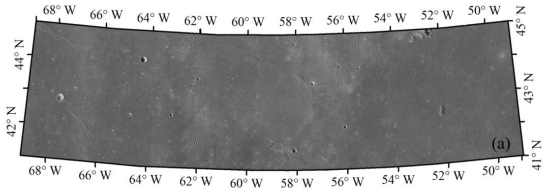
Fig.1. The high-resolution base map of the CE-5 landing area generated from LRO NAC images (Image by AIR)
The craters within the CE-5 landing area were visually identified and manually digitized from the above mosaic with an ArcGIS extension named "Crater Tools". When manually digitizing the craters, the DOM mosaic was visualized in a local tangent plane projection to make it convenient and precise for crater mapping.
Three points along the crater rim were identified to fit a circle representing the crater, which was further refined with the help of SLDEM2015 data. Finally, an elliptical outline representing the crater rim was fitted, and a number of parameters, such as the diameter and the ratio of depth to diameter, were derived.
As a result, 174297 craters were mapped in this area, with 140796 craters larger than 100 m and 32277 craters larger than 200 m in diameter.
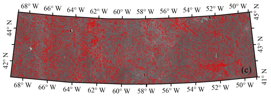
Fig.2. The extracted craters (≥200 m) in the CE-5 landing area overlaying on the LRO NAC DOM mosaic (Image by AIR)
There are nine geologic units in this area according to the previous research, and the catalogue of craters larger than 200 m in diameter is used to date the age of each unit. The crater size-distribution within each geologic unit was used for dating their ages according to the density of crater larger than 1 km in diameter, i.e., N(1), and the established lunar chronology function.
It is found that the geologic unit near the Mons Rümker is the youngest with a model age ~2.02 Ga, the geologic unit near Rümker plateau is the oldest with a model age ~3.49 Ga. At the same time, the derived N (1) provides basis for future refinement of the lunar chronology function.