
Newsroom


A groundbreaking study led by Prof. CHEN Hongsong from the Institute of Subtropical Agriculture of the Chinese Academy of Sciences (CAS) has unveiled the mechanistic influence of soil thickness (as a representative litho-structural factor) on water movement dynamics.
Their findings were published in Journal of Hydrologyand Geophysical Research Letters.
Karst landforms, which are shaped by the dissolution of carbonate rocks, cover about 15% of the Earth's land surface and provide stable water resources to a quarter of the global population. Southwestern China contains the largest exposed karst area globally, where intense dissolution processes have created a distinct surface-underground dual three-dimensional hydrological structure. This unique system exhibits rapid soil water infiltration, prominent preferential flow development, and extreme spatial heterogeneity in hydrological patterns. Under climate change, the dual attributes of rapid infiltration and weak water retention amplify risks of karst drought and flooding in these regions.
Based at the Huanjiang Karst Ecosystem Observation and Research Station of CAS, the researchers conducted a detailed study on hillslope plots using integrated 3D monitoring systems for surface-subsurface hydrology. Through long-term, high-density, and high-frequency (5-minute interval) soil moisture observations, time-series analysis was employed to quantify rainfall response characteristics of both conventional matrix infiltration and preferential flow in slope soils.
The results revealed that rainfall penetrates the soil more rapidly in karst areas, with soil moisture wetting front velocities (1,373 mm/h) significantly exceeding those in non-karst regions (17–610 mm/h). Soil moisture response time and wetting front velocity were found to increase from upslope to downslope and from surface to deeper soil layers.
The study also highlighted the increased variability of infiltration parameters in slopes with thinner soil layers, attributed to the reduced regulation of the hydraulic gradient. Rainfall intensity and amount had a greater impact on infiltration (30.9–63.9%) compared to antecedent soil moisture (12.7–26.1%).
Additionally, increased soil thickness may diminish the topographic and rainfall controls on infiltration processes. These findings underscore the critical role of high-resolution monitoring in characterizing spatial heterogeneity of soil moisture infiltration and quantitatively defining the rapidity of hydrological processes in karst hillslopes.
The researchers also identified two key types of preferential flow: macropore flow and lateral flow at the soil-bedrock interface. They found that macropore flow dominates in karst hillslopes (more than 63%), while interface lateral flow, triggered by short-duration intense rainfall, plays a critical role as well. Interestingly, preferential flow occurrence was more frequent in downslope areas than upslope, due to the spatial variation in soil hydraulic properties. In slopes with thicker soil, a negative correlation was observed between soil depth and preferential flow frequency, whereas no such correlation existed in shallow-soil-covered slopes, where rainfall intensity and antecedent moisture played a more significant role.
These findings highlight the influence of spatial heterogeneity in soil thickness on preferential flow characteristics, further enriching the complex infiltration-runoff theory in karst hillslopes.
"Existing research has extensively explored fundamental characteristics, types, and pathways of soil water infiltration." said Dr. ZHANG Jun, a postdoctoral fellow. "Our new findings will advance the understanding of rainfall-infiltration-runoff mechanisms in karst systems and provide more valuable water resource management strategies in response to climate variability."
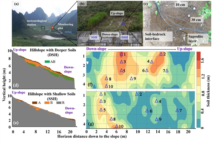
Monitoring plot and meteorological station in the catchment (a), planar photographs of the monitoring plots (b), burial depth of the soil moisture probe (c), excavated profile of the ditches (d) and (e), and arrangement of the soil moisture probes (Δ) in the two plots and the spatial distribution of the soil thickness (f) and (g). (Image by ZHANG Jun)
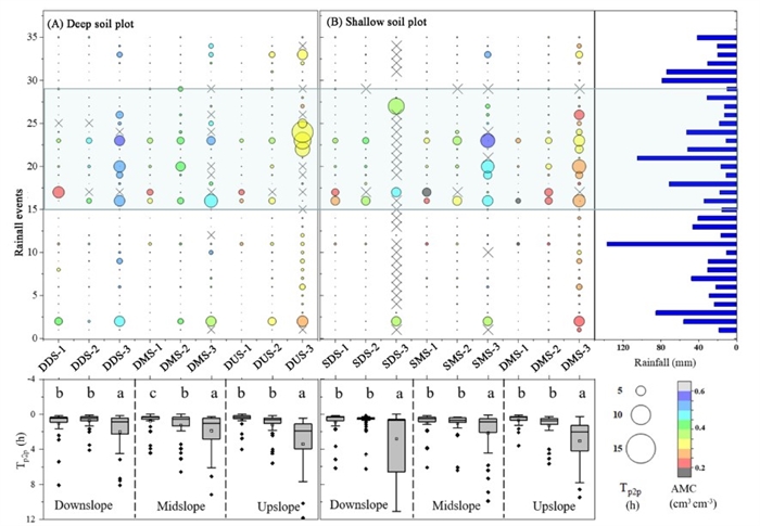
Soil moisture response timing (Tp2p) across hillslopes, the DSP (a) and SSP (b) along with rainfall events (blue bars) over the monitoring period. (Image by ZHANG Jun)
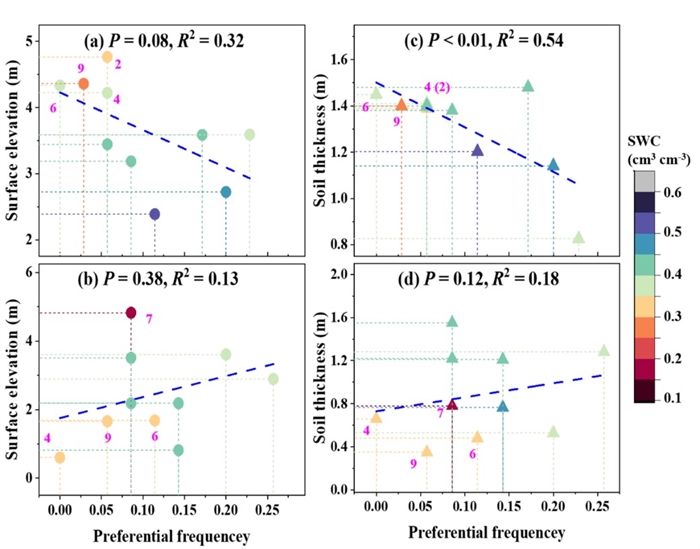
Linear relationship between the surface elevation and soil thickness with the preferential flow frequency on the DSH (a) and (c) and SSH (b) and (d). (Image by ZHANG Jun)
