
Transportation is an important driving factor in land use change. Most researches focus on the relationship between land use and transportation systems within a single city. There are few studies of regionally integrated transportation systems and overall land use patterns.
Recently, researchers from the Institute of Geographic Sciences and Natural Resources Research (IGSNRR) of the Chinese Academy of Sciences (CAS) revealed the spatial relationship of high-speed transportation construction and land-use efficiency and its mechanism in the Shandong Peninsula urban agglomeration. Their findings were published in Journal of Geographical Sciences.
They established an evaluation of high-speed transportation superiority degree, which included the high-speed transportation network, density, and axial radiation, to evaluate the high-speed transportation level and grade of 42 land-based county-level units. They also used a DEA model to calculate the land-use efficiency.
With the aid of GIS and scatter diagram, researchers combined land-use efficiency types with high-speed transportation types to analyze the spatial relationship between them. The results showed that taking the two major cities of Jinan and Qingdao as the hubs, the core surrounding counties present a significant spatial coordination between their land-use efficiency and high-speed transport superiority degree.
The study reveals that high-speed transportation has a positive relationship with land-use efficiency due to the mechanism of element agglomeration and endogenous growth.
This research was supported by the Major Program of National Natural Science Foundation of China.
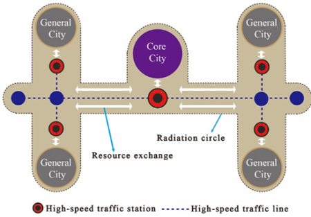
The influence of high-speed transportation on resource allocation (Image by FANG Chuanglin's team)
|
|
ZHANG Yan
Institute of Geographic Sciences and Natural Resources Research
E-mail: zhangyan@igsnrr.ac.cn
Wang Feiyue has won the IEEE ITS Institutional Lead Award for 2010 for their outstanding leadership and contributions in Intelligent Transportation Systems(ITS)research and applications over the last decade. Due to the nature of complexity involved in transportation problems,it is impossible to conduct large scale real or living field experiments for verifying and validating the effectiveness of urban traffic control and management systems. Based the field test results since September 2009,the traffic conditions in the area involved have been significantly improved,with the main road capacity increased by 26% and average queue length decreased by 8%-19% during one year period.
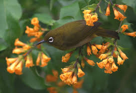
Researchers from Xishuangbanna Tropical Botanical Garden (XTBG), Sri Lanka and India conducted a study in the Sri Lankan and Western Ghats biological diversity hotspot. They aimed to explore the conservation implications of mixed-species bird groups, by examining how mixed-species flocking influenced the response of birds to varying intensities of human land use. They used data from a large-scale study of flocks in Sri Lanka and the Western Ghats of India. The flocks were sampled in three land-use types: inside forest reserves, in buffer areas containing degraded forest or tree plantations, and in agricultural areas.

86-10-68597521 (day)
86-10-68597289 (night)

52 Sanlihe Rd., Xicheng District,
Beijing, China (100864)
Copyright © 2002 - Chinese Academy of Sciences


