
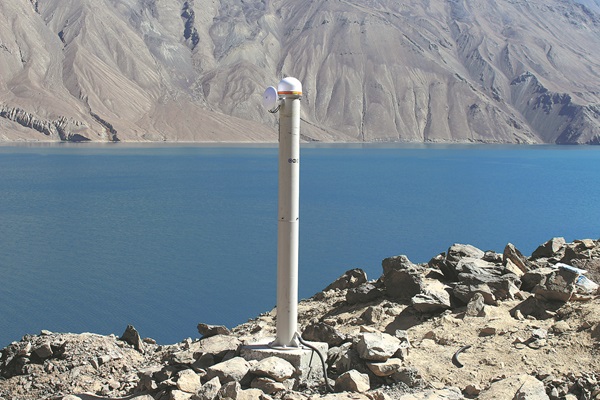
A monitoring tower on the bank of the lake collects data on deformations on the dam. [Photo provided to China Daily]
Along with providing stable navigation services worldwide, the Beidou global satellite navigation system developed by China has been monitoring the deformation of Lake Sarez in the seismically active zone of the Pamir Plateau in eastern Tajikistan for nearly three years, predicting potential earthquakes.
"Forty donkeys, 10 scientists and 30 others spent 10 days transporting the necessary equipment up to the dam at the lake. Finally, over the beautiful lake, we received signals from China's Beidou Navigation Satellite System," said TU Rui, dean of the College of Geodesy and Geomatics at the Shandong University of Science and Technology.
The monitoring system started operating in October 2021, and since its expansion the following year, the Beidou monitoring network at Sarez has been consistently monitoring millimeter-level deformations on the dam and providing data.
"After more than two years of observation, we have noticed a certain degree of deformation in the dam. As the region has entered a dangerous period for the outbreak of a new round of major earthquakes predicted by seismologists, this real-time monitoring and analysis data are of great significance," said TU, the project leader and a former researcher at the National Time Service Center of the Chinese Academy of Sciences.
Sarez is a natural barrier lake that was formed by a landslide after a strong earthquake in 1911. On its northwest side, the Usoi Dam, with a height of 567 meters, was also formed due to a landslide, making it the world's tallest natural dam.
Over the past century, concerns about a potential disaster at Lake Sarez have been growing among Central Asian countries. The Pamir Plateau is in a seismically active zone, and in recent years, incidents of rockfalls on the shores of the lake have occurred due to earthquakes and other factors. So far, no major disaster has occurred.
Currently, there is a 2,000-meter-long structural crack along the right bank of the lake, following the Muzkol mountain range. If the mountain collapses, it could cause flooding, rapidly devastating villages within hundreds of square kilometers, submerging crops and vegetation, according to Wang Weisheng, an expert who also participated in the project.
In 2021, the CAS Research Center of Ecology and Environment of Central Asia organized a joint effort with the CAS National Time Service Center and the CAS Xinjiang Institute of Ecology and Geography to bring domestic technology and analytical methods to Tajikistan. They used Beidou technology to monitor deformations in the Lake Sarez dam.
TU said that in the initial stages of the project, there was no electricity, roads, or internet connectivity around the lake, and the Chinese-Tajik scientific team had to work step by step to resolve these problems.
In early April 2021, the CAS Research Center of Ecology and Environment of Central Asia organized a technical team to construct a simulation system and conduct tests at the Fukang Desert Ecosystem National Field Scientific Observation and Research Station in the Xinjiang Uygur autonomous region. They conducted tests simulating special scenarios such as prolonged power outages and the loss of communication links, repeatedly analyzing reasons for any issues and updating the software and hardware, Wang said.
"In terms of equipment, we focused on lightweight and low-energy consumption to adapt to the extreme local environment," TU said.
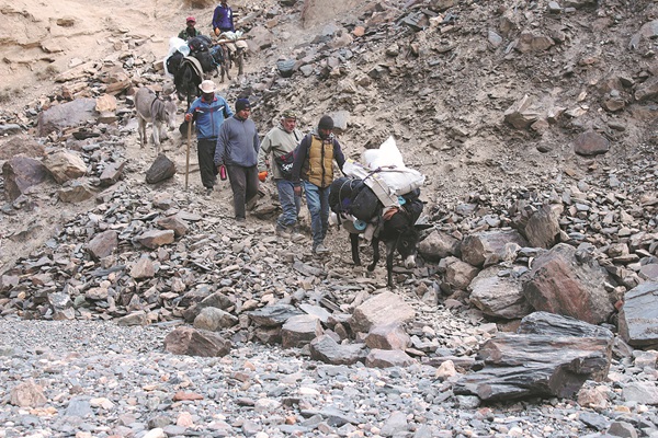
Members of the Chinese-Tajik scientific team climb to the Lake Sarez area in 2021. [Photo provided to China Daily]
To address the power supply issue, the research team capitalized on the strong sunlight on the plateau for photovoltaic power generation, storing the energy in batteries to ensure continuous power supply that could persist in cloudy, rainy, or snowy weather for as long as three months.
The team also built a local network on the dam, enabling data exchange within the devices. Through a satellite communication platform, aggregated data was transmitted via satellite to the Dushanbe subcenter of the Research Center for Ecology and Environment of Central Asia of the CAS, as well as Tajik emergency departments. The subcenter then conducted a comprehensive analysis of the deformation data, achieving real-time reporting of deformation warnings, Wang said.
"In fact, the technological breakthrough did not happen overnight this year. It was a concentrated effort of our accumulated technology over the past decades," TU said.
In 2019, the first China-Central Asia Beidou Cooperation Forum was held, laying the foundation for satellite navigation cooperation between China and Central Asia, TU said.
Apart from disaster prevention, the Beidou system has also been integrated into transportation, public safety and weather forecasting in the Central Asian region.
"From the Silk Road in history to the Belt and Road Initiative, China has established a solid foundation of trust with Central Asian countries, and cooperation in economics, technology, culture and security continues to deepen," TU said. "The extensive application of the Beidou system will undoubtedly further facilitate the deepening development of this cooperation."
Against this backdrop, the joint Chinese-Tajik team conducted research on the development of integrated data collection equipment and networking communication strategies in complex environments, as well as research on high-precision positioning data processing and deformation analysis techniques using Beidou technology.
The team ultimately established a Beidou deformation monitoring system suitable for specific conditions at Lake Sarez, achieving high-precision deformation monitoring of the Usoi Dam and international disaster reduction cooperation. (China Daily)

The Beidou Navigation Satellite System -- China's independently developed global navigation satellite system (GNSS) -- will have a constellation of 35 satellites and be ready to provide global users with geo-positioning by 2020, an insider said Tuesday.
China is planning to use its domestically-operated satellite navigation system to help log and detect possible leaks in gas pipelines, the National Administration of Surveying, Mapping and Geoinformation (NASMG) announced on Friday. The program, using the BeiDou Navigation Satellite System (BDS), will soon be put into place in more than 100 cities. It is already operational in "at least 10 cities", according to a statement from the NASMG.

86-10-68597521 (day)
86-10-68597289 (night)

52 Sanlihe Rd., Xicheng District,
Beijing, China (100864)
Copyright © 2002 - Chinese Academy of Sciences


