
Recently, researcher JIANG Liming from the Institute of Geodesy and Geophysics (IGG), Chinese Academy of Sciences, in cooperation with Professor LIN Hui from the Institute of Space and Earth Information Science, Chinese University of Hong Kong, made significant progress in the investigation of ground surface deformation and precision monitoring through Interferometry Synthetic Aperture Radar (InSAR) technology.
InSAR is a rapidly developing spatial geodetic technique using time-series radar image phase signals to acquire precise three-dimensional surface deformation information deposited on the ground, earthquakes, volcanoes, glaciers, frozen soils, etc.
In order to overcome the insufficiency of conventional time series InSAR technology (such as PSI method), and to intensively monitor the natural surface (such as reclamation area) lacking artificial buildings, the distributed scatterer timing InSAR (DSI) technology has been used and achieved some progress. However, the solution efficiency becomes an important bottleneck restricting the existing DSI applications.
In response to this problem, the researchers proposed a DSI improvement strategy combining FaSHPS DS recognition algorithm and feature decomposition phase optimization algorithm to achieve significant surface deformation intensive monitoring, while significantly improving the efficiency of calculation.
The method has been successfully used in Hong Kong International Airport, uneven land subsidence monitoring of large reclamation infrastructure such as the Hong Kong Science Park.
The results of the investigation indicated that there were significant uneven land subsidences (3 mm/year to 20 mm/year) in the reclamation areas of the Hong Kong International Airport and the Hong Kong Science Park. The density of monitoring points has been greatly improved (about 360,000/km2), about 8 times of the PSI method, as shown in Figure 1.
In addition, compared with the existing DSI method, the improved DSI method has a significantly improved solution efficiency (target point recognition and phase optimization are improved by about 30 times and 20 times, respectively).
The improved DSI method not only provides important technical support for the monitoring and early warning of uneven settlement of major infrastructure in the reclamation area, but also has broad application prospects in the high-efficiency and precise monitoring of natural surface deformation such as land subsidence, tectonic movement and permafrost degradation in large-scale coastal zones.
The relevant results entitled "Monitoring Coastal Reclamation Subsidence in Hong Kong with Distributed Scatterer Interferometry" were published in Remote Sensing.
The research was funded by the National Natural Science Foundation of China, the National Natural Science Foundation of China, and the National Key Research and Development Program.
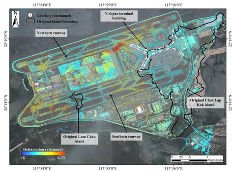
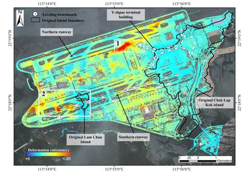
Figure 1 comparison of InSAR monitoring results of ground subsidence sequence at Hong Kong international airport (a) PSI, (b) DSI. (Image by IGG)

86-10-68597521 (day)
86-10-68597289 (night)

52 Sanlihe Rd., Xicheng District,
Beijing, China (100864)
Copyright © 2002 - Chinese Academy of Sciences


