Climate change and human activities significantly impact the underlying permafrost and the active layer throughout the Qinghai-Tibet Engineering Corridor (QTEC), which may reflect the changes in the alpine ecosystem of the Qinghai-Tibet Plateau (QTP).
However, most previous studies focused on the impacts of climate change on the ecologically important QTP, and little attention has been paid to the much smaller area of the QTEC.
Recently, scientists from Northwest Institute of Eco-Environment and Resources (NIEER) of the Chinese Academy of Sciences used the normalized difference vegetation index (NDVI) as an indicator of alpine vegetation activity and the permafrost active layer thickness (ALT) as an indicator of permafrost dynamics, to understand the impacts of climate change, human activity, or their combination on the alpine ecosystem in the QTEC.
They collected research data to confirm increases in the mean annual air temperature, total precipitation, and downward radiation and a decreasing trend in surface wind speed over the QTEC.
The research results indicate that the QTEC experienced a significant warming and wetting trend. The increased precipitation improved the alpine vegetation activity across much of the QTEC. However, the increased air temperature accelerated the thawing of permafrost.
Besides, research results also suggest that the improvement of alpine vegetation cannot necessarily prevent permafrost degradation caused by warming.
However, vegetation deterioration was more severe in the southern zone near the Qinghai-Tibet Railway (QTR) and Qinghai-Tibet Highway (QTH). The deterioration of the alpine vegetation in the area was due to increases in the numbers of visitors and permanent residents and greater economic activities.
Therefore, although the trend of increasing air temperature and precipitation suggested a warming and wetting phenomenon over the QTEC, increased human activities could render the ecosystems more vulnerable to permafrost degradation.
The study entitled "The impacts of climate change and human activities on alpine vegetation and permafrost in the Qinghai-Tibet Engineering Corridor" was published in Ecological Indicators.

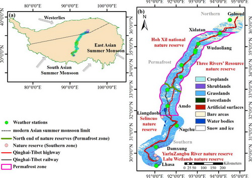
Geography of the QTEC area. (a) Location of the QTEC (central area). (b) Some of the related weather station (green points), Qinghai-Tibet Railway (black line), Qinghai-Tibet Highway (red line), permafrost zone (pink box), and the southern end of the nature reserves (green line), and the northern end of the nature reserves (the top of the pink box). (For interpretation of the references to color in this figure legend, the reader is referred to the web version of this article.) (Image by NIEER)

86-10-68597521 (day)
86-10-68597289 (night)

52 Sanlihe Rd., Xicheng District,
Beijing, China (100864)

