
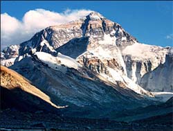
The State Bureau of Surveying and Mapping (SBSM) announced in a press conference held on Oct.9 in Beijing that its new measurement of Mount Qomolangma, also known as Mount Everest, is 8,844.43 meters above sea level.
Chen Bangzhu, director general of SBSM said: "Authorized by the State Council, and on behalf of the State Bureau of Surveying and mapping, I now declare the official figures of the 2005 Qomolangma measurement. The peak's summit is 8844.43 meters above sea level, with an error margin of 0.21 meters. The ice cover on the top is 3.5 meters. The figure announced in 1975 will no longer be used."
The newly measured height is 3.7 meters shorter than 8,848.13 meters, a figure obtained from the previous measurement in 1975. However, the mountain is still the highest one in the world. The improved technology, such as the ice radar detector and advanced GPS system, has made the data of current measurements more precise, he added.
To help make the measurement, a scientific expedition was carried out in May by a team of Chinese experts, including those from CAS. By June 12, all field data had been sent to the SBSM's Geodesic Survey Data Processing Center in Xi'an, the capital of Shaanxi Province for data processing and indoor analysis. Experts from CAS, the Bureau of Surveying and Mapping under the Headquarters of the PLA General Staff and Wuhan University were then invited to double-check the results.

86-10-68597521 (day)
86-10-68597289 (night)

86-10-68511095 (day)
86-10-68512458 (night)

cas_en@cas.cn

52 Sanlihe Rd., Xicheng District,
Beijing, China (100864)
Copyright © 2002 - Chinese Academy of Sciences


