Newsroom


A collaborative research team has improved visual localization and topographic mapping techniques that enable China's Zhurong rover to navigate and conduct scientific investigations on Mars. These techniques played a crucial role in the success of the Tianwen-1 mission, which is China's first independent interplanetary exploration effort.
China's Tianwen-1 mission, launched in July 2020, aimed to map the Martian surface, analyze geological structures, and study the planet's climate and environment. A key component of this mission was the Zhurong rover, which landed in southern Utopia Planitia on May 22, 2021. The rover's ability to traverse the Martian terrain and conduct in-situ scientific investigations depended heavily on accurate localization and high-resolution topographic mapping.
In this study, the researchers developed several innovations to enhance Zhurong's navigation system, including vignette correction and online camera mast calibration techniques, which improved the quality of images captured by the rover's Navigation and Terrain Cameras. These enhancements allowed for the creation of high-resolution 3D topographic maps with centimeter-level accuracy, which were critical for obstacle analysis and rover path planning.
Furthermore, by integrating cross-site visual localization and digital orthophoto map matching, the researchers refined the rover's position to within an accuracy of 0.50% relative to the traverse length, significantly better than the 3.11% accuracy of the rover's onboard dead-reckoning system.
The study indicated that the Zhurong rover traveled a total distance of 2,009 meters, which is 88 meters more than the 1,921 meters recorded by the onboard odometer. This discrepancy was caused by wheel slippage due to the downslope trend of the traverse, emphasizing the importance of accurate localization for understanding the rover's movement on Mars.
Additionally, the high-resolution topographic maps facilitated a detailed analysis of geological features, such as Transverse Aeolian Ridges and impact craters, providing valuable insights into Mars' geological history and climatic evolution.
This study was published in the IEEE Journal of Selected Topics in Applied Earth Observations and Remote Sensing. The researchers are affiliated with the Aerospace Information Research Institute of the Chinese Academy of Sciences and the Beijing Aerospace Control Center.
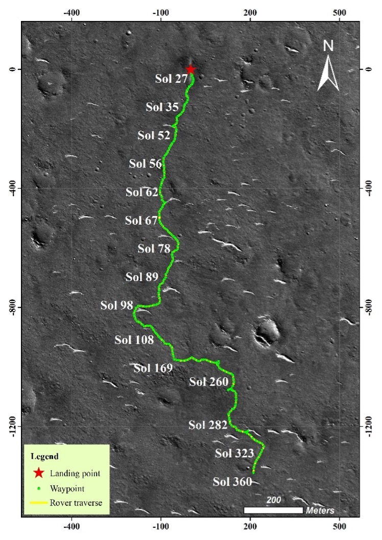
The traverse of Zhurong rover generated from visual localization. (Image by AIR)