About six gigatons -- roughly 12 times the mass of all living humans -- of carbon appears to be emitted over land every year, according to data from the Chinese Global Carbon Dioxide Monitoring Scientific Experimental Satellite (TanSat).
Using data on how carbon mixes with dry air collected from May 2017 to April 2018, researchers developed the first global carbon flux dataset and map. They published their results on July 22 in
Advances in Atmospheric Sciences.
The map was developed by applying TanSat's satellite observations to models of how greenhouse gases are exchanged among Earth's atmosphere, land, water and living organisms. During this process, more than a hundred of gigatons of carbon are exchanged, but the increase in carbon emissions has resulted in net carbon added to the atmosphere -- now at about six gigatons a year -- which is a serious issue that contributes to climate change.
"In this study, we introduced the first implementation of TanSat carbon dioxide data on carbon flux estimations," said YANG Dongxu, first author and a researcher in the Institute of Atmospheric Physics (IAP) of the Chinese Academy of Sciences. "We also demonstrate that China's first carbon-monitoring satellite can investigate the distribution of carbon flux across the globe."
While satellite measurements are not as accurate as ground-based measurements, satellite measurements provide continuous global observation coverage that provides additional information not available from limited or varied surface monitoring stations. "For example, a monitoring station in a city may report very different observations compared to a station in a remote village, especially if they are in drastically different climates," said co-author WANG Jing, also an IAP researcher.
"The sparseness and spatial inhomogeneity of the existing ground-based network limits our ability to infer consistent global- and regional-scale carbon sources and sinks," said co-author FENG Liang, researcher with the National Centre for Earth Observation at the University of Edinburgh. "To improve observation coverage, tailor-made satellites, for example, TanSat, have been developed to provide accurate atmospheric greenhouse gas measurements."
The data from these satellites, which includes TanSat, Japan's GOSAT and the United States' OCO-2, and future missions, will be used to independently verify national emission inventories across the globe.
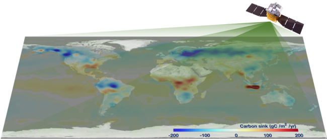
The first global carbon flux map derived by TanSat observation. (Image by YANG Dongxu)
"This verification method will be helpful to better understand carbon emissions in real time, and to help ensure transparency across the inventories," said co-author LIU Yi, a senior researcher in IAP.
TanSat, funded by the Ministry of Science and Technology of China and the China Meteorological Administration, was launched in December 2016.


