
Newsroom


Researchers from the Aerospace Information Research Institute of the Chinese Academy of Sciences (AIRCAS) used satellite images collected across the growing season to map shrub cover in the grasslands of Inner Mongolia, China. By tracking seasonal differences in growth, they were able to distinguish shrub patches from dense grass, which can look similar in a single image.
The study was recently published in International Journal of Digital Earth.
As shrubs spread into semi-arid grasslands, they can alter which plants grow there and how much forage is available to livestock. Mapping shrub cover can help land managers track that spread.
The earliest stages of encroachment are also the hardest to detect. Where shrubs are small and scattered, a single satellite pixel may contain a mixture of shrubs, grasses, and bare soil.
The team tested its method in grasslands near Xilinhot in northern China's Inner Mongolia Autonomous Region. Combining PlanetScope imagery at three-meter resolution with a deep learning model called U-Net, the researchers compared their estimates against drone surveys and very high-resolution imagery.
The fine spatial detail allowed the model to capture the shapes of shrub patches. By incorporating observations at 15-day intervals, the model could also exploit differences in the timing of growth between shrubs and grasses. Compared with single-period imagery, the seasonal observations increased the proportion of variation in shrub cover the model could explain (R2) by about 17%.
The model also preserved fragmented shrub patches better than methods that estimated cover one pixel at a time. Its estimates were less reliable for plots excluded from training, and sparse shrubs remained difficult to detect.
More reliable estimates at low shrub cover would help grassland managers identify encroachment while shrubs are still scattered.
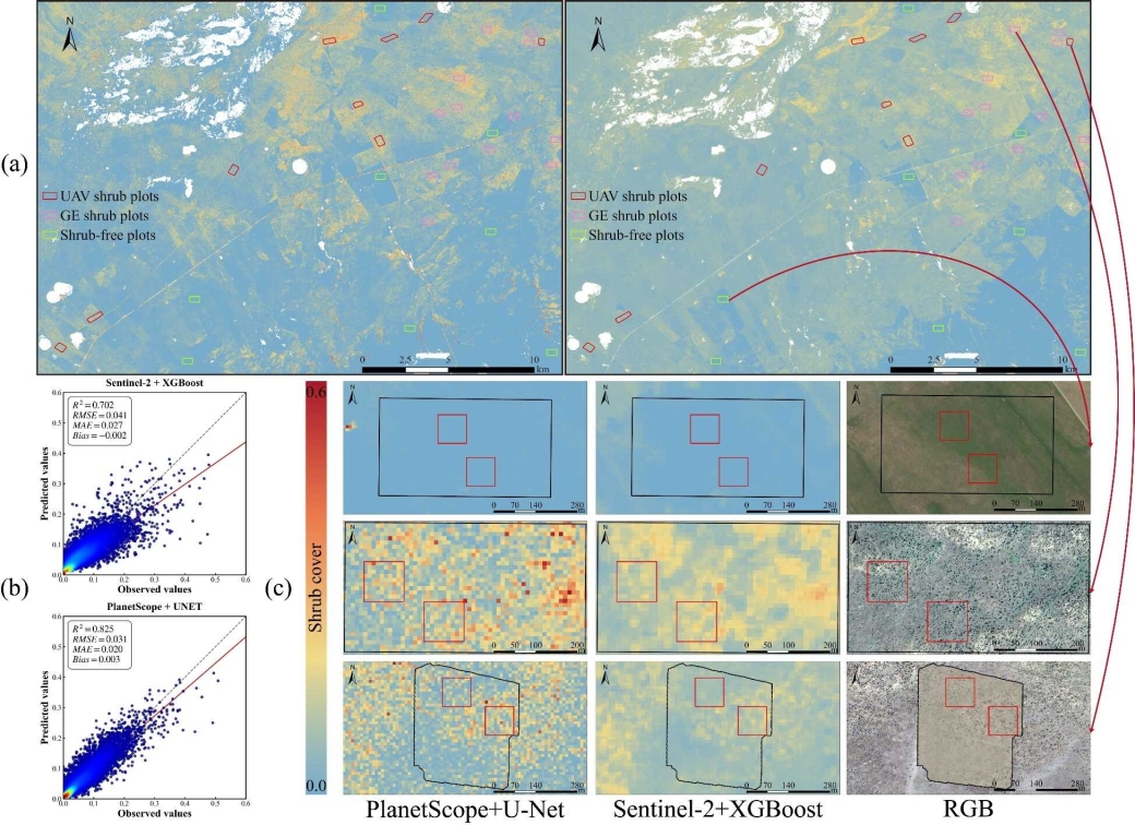
Shrub cover estimated from PlanetScope imagery using U-Net and from Sentinel-2 imagery using XGBoost. (Image by AIRCAS)
