
Newsroom


A research team led by Prof. LI Qiangzi and Associate Researcher DU Xin from the Aerospace Information Research Institute of the Chinese Academy of Sciences (AIRCAS), has developed a 10-meter-resolution maize-yield dataset covering Northeast China for the period 2019-2024. The dataset delivers field-scale detailed maize-yield information across the region.
The findings were recently published in Earth System Science Data.
Northeast China ranks among China's key maize-producing zones and serves as a vital commercial grain base. Reliable crop-yield data is critical for grain-output monitoring, agricultural-loss assessment and agricultural management support. Yet existing official yield statistics and remote-sensing products mostly operate at relatively coarse spatial resolutions, making it hard to capture yield variations between individual farm fields.
To address this challenge, the team built a yield-estimation framework integrating the WOFOST crop-growth model and a Gated Recurrent Unit (GRU) deep-learning model. The WOFOST model represents the physiological processes of maize yield formation under diverse environmental and farm-management conditions, while the GRU model learns yield dynamics derived from Sentinel-2 vegetation observations. Notably, this framework requires no in-situ field yield measurements for model training, which makes it well-suited for large-scale yield mapping in regions with sparse ground observations.
The resulting dataset generates annual 10-meter maize-yield estimates spanning Heilongjiang, Jilin, Liaoning and eastern Inner Mongolia from 2019 through 2024. Independent field observations collected between 2022 and 2024 show strong consistency with mapped yield outputs, validating the framework's capacity to capture field-level yield variability.
High-resolution maps reveal pronounced spatial disparities in maize yields across Northeast China. Higher yields concentrate mainly in major agricultural plains including the Songnen Plain, Liaohe Plain and Sanjiang Plain. By contrast, lower yields are more common in northern hilly zones and the semi-arid western parts of the study area. The maps also capture substantial year-over-year fluctuations in maize production. In particular, yield maps reflect sharp production drops across parts of southern Heilongjiang and northern Jilin triggered by typhoons and floods in 2023.
This dataset offers a new high-resolution data resource for maize-yield and agricultural-disaster monitoring over Northeast China. It supports real-world applications covering precision agriculture, agricultural insurance, disaster impact assessment, black-soil conservation and food-security surveillance.
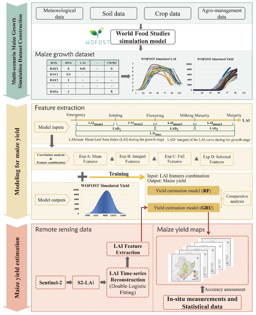
Maize yield estimation framework for Northeast China. (Image by AIRCAS)
