
Newsroom


A recent study published in Remote Sensing of Environment has generated the first 10-meter dynamic water dataset (DWH10) for the Hindu Kush Himalaya (HKH) region, showing that existing global water products may substantially underestimate surface water extent in mountainous areas.
The study was carried out by a collaborative team from the University of Hong Kong and the Aerospace Information Research Institute (AIR) of the Chinese Academy of Sciences (CAS). Under the leadership of Profs. LU Shanlong and CHEN Bin, the team developed a Water Dynamic Tracking (WDT) framework that combines SDGSAT-1 nighttime thermal infrared observations with Sentinel-2 multispectral imagery.
This framework reduces terrain-shadow interference and makes it possible to generate the DWH10 dataset for the HKH region—often called the "Asian Water Tower," a region that supplies critical water resources to nearly two billion people.
Mountain shadows often exhibit spectral characteristics that resemble surface water in optical imagery, causing persistent confusion between shadowed land and water bodies. Because mountain shadows originate from uneven solar illumination during daytime, nighttime thermal observations are largely free from such effects and provide more stable thermal characteristics.
By leveraging SDGSAT-1 thermal data and Sentinel-2 multispectral imagery, the team incorporates nighttime thermal signals into water mapping workflows, substantially suppressing terrain-shadow effects and enabling high-resolution monitoring of dynamic surface water in complex mountainous environments.
The study demonstrates that nighttime thermal infrared observations can provide information beyond conventional optical imagery. With these observations integrated, scientists can reduce terrain-shadow interference and reveal dynamic water processes in regions where traditional approaches often struggle.
The findings reveal distinct spatial patterns in surface water distribution across the HKH. DWH10 identified approximately 145,000 km2 of surface water, of which 53% was stable water and 47% was seasonal dynamic water. Dynamic water bodies were primarily concentrated in mountain valleys and low-altitude regions, whereas large stable lakes mainly occurred across the central Tibetan Plateau.
Validation results further demonstrate the dataset's strong performance. DWH10 achieves an overall accuracy of 95.4% and a Kappa coefficient of 0.93, substantially outperforming existing products such as JRC-GSW, GLADWater, and ESA10. The advantages are particularly evident in areas with severe terrain shadows and small river systems.
Compared with datasets currently used for SDG 6.6.1 assessments, DWH10 provides more complete observations and offers stronger support for evaluating changes in water ecosystems in complex terrain environments.
Profs. LU and CHEN said, "This study demonstrates the considerable potential of SDGSAT-1 nighttime thermal infrared observations for monitoring surface water dynamics in mountainous regions. It opens a new pathway for integrating nighttime thermal observations into future satellite-based environmental monitoring systems."
This research was supported by China's National Key R&D Program under the project titled "Remote Sensing-Based Assessment and Capacity Building for Sustainable Development in the Hindu Kush Himalaya Region."
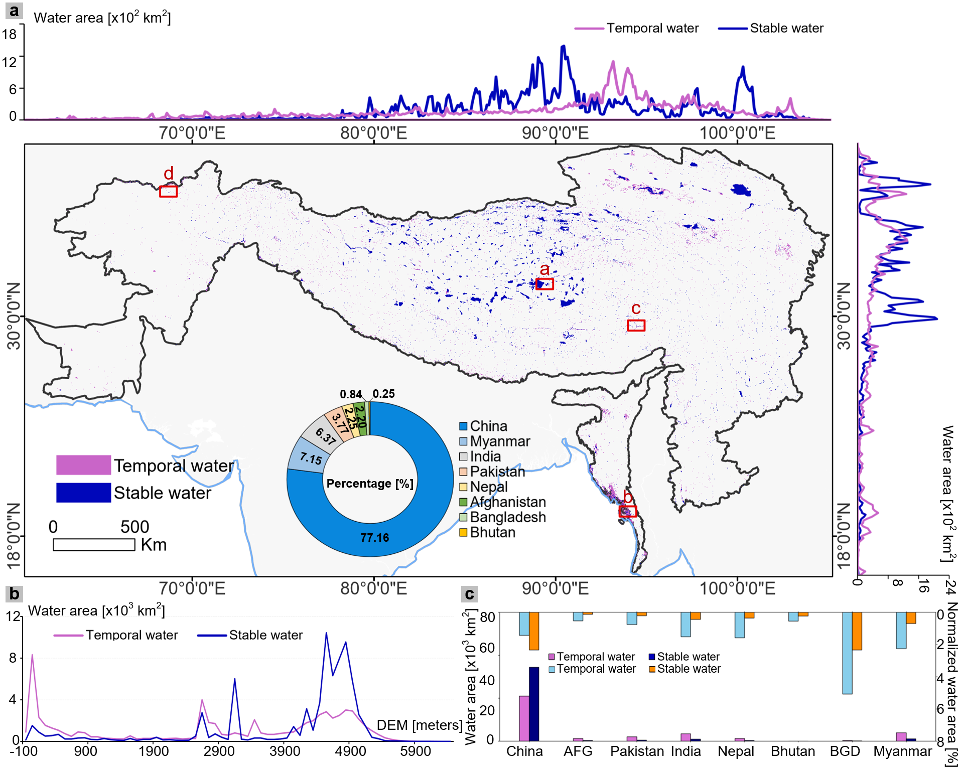
Spatial distribution of DWH10 and statistics of surface water area across the HKH region. AFG denotes Afghanistan and BGD denotes Bangladesh. (Image by AIR)
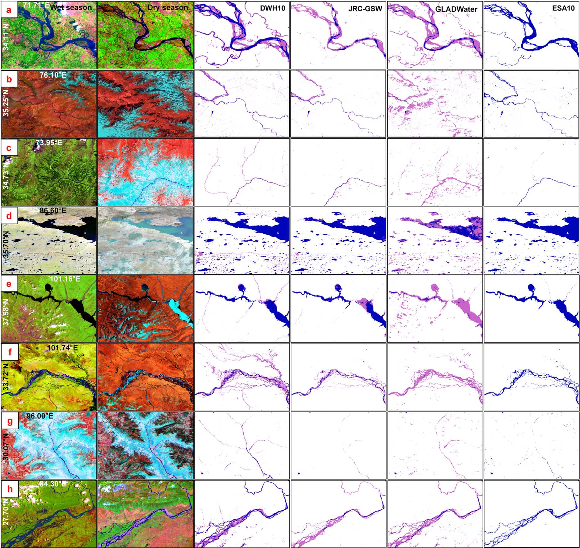
Comparison of DWH10, JRC-GSW, GLADWater, and ESA10 results in representative regions. (Image by AIR)

