
Newsroom


Xinjiang is China's leading cotton-producing region. Timely information on cotton distribution is crucial for cultivation management, irrigation scheduling, and agricultural insurance.
Now, researchers from the Aerospace Information Research Institute (AIR) of the Chinese Academy of Sciences (CAS), in collaboration with Shihezi University, have developed a method that pushes the earliest detectable identification window of cotton in Xinjiang forward to the sowing–seedling stage.
The study was published in Remote Sensing of Environment.
Traditional approaches of detection depend largely on phenological signals that become visible only after canopy development, which limits their value for early decision-making. To address this problem, the team turned away from conventional crop-growth patterns and instead looked at signals left by farming practices.
In Xinjiang, cotton is widely grown with mechanized plastic mulching and under-film drip irrigation. The researchers observed that during the sowing–seedling stage, cotton fields typically show a higher proportion of plastic-mulched area within 10‑m pixels than other crops—offering a distinctive early clue for identification.
Using Sentinel‑2 imagery (at 10‑m spatial resolution), the team produced early‑season cotton maps across Xinjiang. Their method identified cotton fields roughly 4 to 4.5 months before harvest, with an overall accuracy of 84.70% and an F1‑score for cotton of 88.16%. Compared with in‑season phenology‑based techniques, this approach significantly improves mapping timeliness.
The study was supported by the National Natural Science Foundation of China, the Xinjiang Production and Construction Corps Science and Technology Program Project, and the Youth Innovation Promotion Association of the Chinese Academy of Sciences.
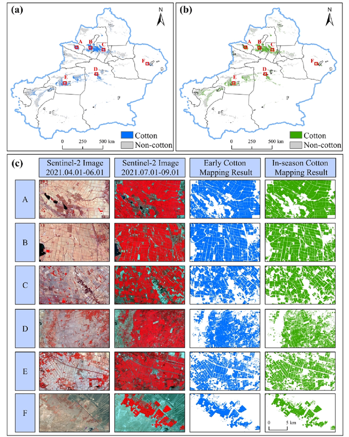
Early-season maps of cotton in Xinjiang: (a) early-season mapping; (b) in-season mapping; (c) spatial details of cotton maps for six selected regions. (Image by AIR)
