
Newsroom


A research team from the Aerospace Information Research Institute (AIR) of the Chinese Academy of Sciences (CAS), jointly with Changsha University of Science and Technology and Tsinghua University, has proposed a systematic and unified framework that combines Light Detection and Ranging (LiDAR) remote sensing with Weakly Supervised Learning (WSL).
The study provides a comprehensive review that bridges the traditional gap between LiDAR data interpretation and large-scale parameter inversion, providing scalable technical pathways to alleviate the high costs of manual data annotation in Earth observation.
The findings were published in the ISPRS Journal of Photogrammetry and Remote Sensing.
LiDAR has emerged as a pivotal technology for high-precision 3-dimensional (3D) Earth observation, with wide applications in terrain mapping, ecological monitoring, and urban modeling. However, the field still faces two major challenges.
First, interpreting massive LiDAR point clouds requires exhaustive, labor-intensive manual 3D annotations. Second, utilizing LiDAR for large-scale parameter inversion, such as estimating forest canopy height, aboveground biomass, or water depth, relies heavily on costly and sometimes hazardous field surveys. In addition, differences among airborne, terrestrial, and spaceborne sensors, as well as environmental conditions, can create significant domain shifts, which limit model transferability across regions.
To tackle these challenges, the researchers introduced weakly supervised learning, a machine learning approach that builds robust predictive models from limited, coarse, or noisy labels, into LiDAR remote sensing applications.
"This paper goes beyond the traditional view that treats interpretation and inversion as separate tasks," the research team noted. "It offers a systematic review of recent advances in LiDAR remote sensing from a unified WSL perspective."
The researchers have categorized representative WSL approaches into four major types: incomplete supervision, which relies on sparse point labels; inexact supervision, which uses coarse scene-level tags or bounding boxes; inaccurate supervision, which handles noisy labels; and cross-domain supervision, which enables adaptation across sensors and geographic regions.
For LiDAR data interpretation tasks—including 3D semantic segmentation and object detection—the study highlights how techniques such as pseudo-labeling, consistency regularization, and self-training allow deep learning networks to extract accurate geometric and semantic information from highly limited labels.
For large-scale parameter inversion, the researchers have demonstrated that sparse yet physically grounded spaceborne LiDAR measurements—such as those from NASA's GEDI and ICESat-2 missions—can serve as critical weak supervisory signals. When fused with continuous optical or radar satellite imagery, these sparse footprints guide the joint learning process, enabling the generation of high-resolution, continuous maps of forest biomass, canopy height, and shallow water bathymetry across vast, unmeasured regions.
The study stresses that WSL methods cannot be simply transplanted from 2D image processing. LiDAR data is inherently unstructured and sparse, and lacks the spectral and textural priors present in standard images. To address these modality-specific challenges, recent advancements have integrated geometric constraints, elevation-aware modules, and spatiotemporal dynamics to adapt WSL to the unique physical properties of LiDAR.
Looking ahead, the researchers have identified the integration of foundation models—including Large Language Models and Vision-Language Models—as a highly promising direction. While native 3D foundation models remain constrained by insufficient large-scale pre-training datasets, WSL could help bridge this gap by injecting precise 3D geometric priors into existing semantic models, thus enabling broader reasoning capabilities while further reducing labeling costs.
The team has also called for the development of large-scale, multimodal, and cross-platform datasets equipped with rigorous, region-held-out evaluation protocols, aimed at better assessing model generalization capabilities in complex, real-world Earth observation scenarios.
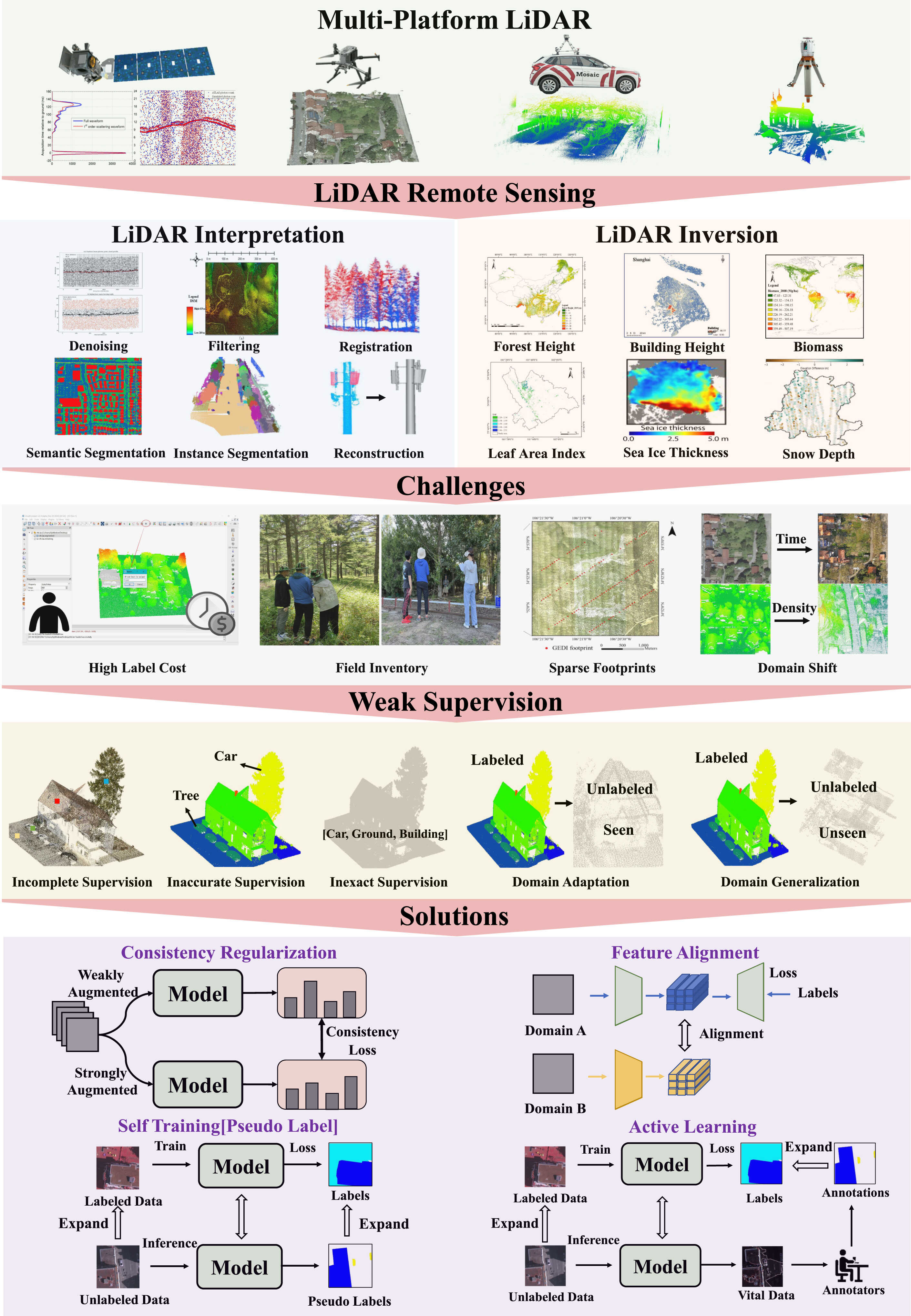
An overview of LiDAR remote sensing meets weak supervision. (Image by AIRCAS)
