
UAV (Unmanned Aerial Vehicle) Aerial Remote Sensing Technology has been applied by Chengdu Institute of Mountain Hazards and Environment (IMHE), CAS in investigation and data collection in Wenchuan earthquake, which made an important contribution to the remote sensing monitoring and assessment of Wenchuan earthquake.
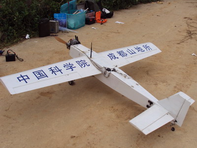 |
| UAV hardware platform (Picture/IMHE) |
Based on the images taken by UAV technology, IMHE submit an “Analysis Report of Wenchuan Earthquake Damage” to the Central with Institute of Remote Sensing Application (IRSA), CAS and University of Electronic Science and Technology of China. This report plays an important part in earthquake relief and reconstruction work, which was honored by both Sichuan government and CAS.
After Wenchuan earthquake in 2008, IMHE formed a UAV aerial remote sensing technology team and develop an UAV hardware platform and grand station software. Digital Mountain and Remote Sensing Applications Center was in charge of research and development of UAV technology.
IMHE has gained great experience in UAV technology in the last two years.
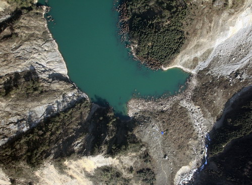 |
| UAV image (taken in Dujiangyan City)(Picture/IMHE) |
First, UAV team has grasped the technology of taking off & landing in complex mountain areas and decreasing the occurrence of accident and loss significantly.
Secondly, UAV team optimizes the preprocessing method of remote sensing images and overcome image metamorphosis.
Thirdly, UAV team carried out remote sensing image interpretation and recognition experiment. And the UAV technology is verified to be valid by comparing and analyzing to the field investigation and experience.
UAV team will continue deepening research and improving conditions to make it more available in mountain hazards and environment research.

86-10-68597521 (day)
86-10-68597289 (night)

86-10-68511095 (day)
86-10-68512458 (night)

cas_en@cas.cn

52 Sanlihe Rd., Xicheng District,
Beijing, China (100864)
Copyright © 2002 - Chinese Academy of Sciences


