中文 |

News Updates

CAS satellite station to offer remote-sensing data from IRS-P6

Apr 24, 2005


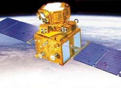
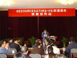
The CAS Remote-Sensing Satellite Ground Station has set up a system for receiving and processing the data from IRS-P6, a state-of-the-art remote sensing satellite developed by India. The announcement was made at a press conference held on April 22 in Beijing.


    After nearly one year of hard work, the CAS Remote-Sensing Satellite Ground Station has set up a system for receiving and processing the data from IRS-P6, a state-of-the-art remote sensing satellite developed by India. The announcement was made at a press conference held on April 22 in Beijing.

    Launched on Oct 17, 2003, IRS-P6 has a LISS-IV camera with a spatial resolution of 5.8 meters, an improved version of LISS-III and an advanced Wide Field Sensor. Apart from agriculture, its data could also be used in city planning, disaster control and map-making. For the time being the station could provide its users with remote sensing data from a total of 12 satellites.
Contact Us
  • 86-10-68597521 (day)

    86-10-68597289 (night)

  • 86-10-68511095 (day)

    86-10-68512458 (night)

  • cas_en@cas.cn

  • 52 Sanlihe Rd., Xicheng District,

    Beijing, China (100864)

Copyright © 2002 - Chinese Academy of Sciences