
Compared with the limited amount of in situ measurements of snow depth or snow water equivalent (SWE) that are usually provided by sparse meteorological stations, satellite-based snow cover estimates have the potential to produce spatiotemporal patterns of snow cover at a larger scale.
Among various such products, MODIS snow cover product is most widely used. It is produced based on the Normalized Difference Snow Index (NDSI) to distinguish snow from other land cover types, and those with NDSI ≥ the NDSI threshold are considered as snow covered.
NASA has recently published MODIS snow cover product version 6 (V6) to replace V5 with significant revisions. A restored band 6 is in place of the previously used band 7 in the calculation of NDSI for Aqua.
In V5, the pixels with surface temperature greater than 283 K are considered as snow-free pixels, whereas V6 considers the effects of elevation that for locations with altitudes ≥ 13 00 m, the "snow" pixels with surface temperature ≥ 283 K will not be reversed but be flagged as "warm snow". The most important one is that the binary and fractional snow cover estimates are no longer available and only the NDSI is provided.
Several studies have used 0 as the NDSI threshold to calculate snow cover since V6 was released, because positive NDSI indicates there is some snow present in the pixel. However, the minimum valid NDSI of V6 is actually 0.1, and that of V5 is 0.4.
Focusing on how to select a reasonable NDSI threshold for use of V6 in China, Dr. ZHANG Hongbo from the Institute of Tibetan Plateau Research of the Chinese Academy of Sciences (ITPCAS) and his colleagues evaluated the accuracy of V6 in China and compared it with V5, using three kinds of NDSI thresholds and six types of evaluation metrics, based on the snow depth observations from more than 200 meteorological stations.
The results showed that the NDSI threshold of 0.1 was more reasonable than that of 0.4 for use in China (Figure 1). Though locally optimal NDSI threshold shows the best accuracy, a locally optimal NDSI threshold is usually unknown for a specific area.
Terra V6 was comparative with Terra V5, but Aqua V6 was superior to Aqua V5 (Figure 2), which was very likely because V6 uses restored band 6 to calculate NDSI.
The revised temperature screen algorithm of V6 was found to be problematic in China, especially for the Tibetan Plateau, i.e. most of the so called "warm snow" pixels were snow free actually. In addition, V6 presented much lower accuracy in the TP (Figure 3), due to its shallower daily snow depth and the pixel heterogeneity problem resulted from complex terrain and higher mean altitude. To summary, the NDSI threshold of 0.1 is recommended for use in China.
The study, published in Science of the Total Environment, was supported by the National Natural Science Foundation of China and China Postdoctoral Science Foundation.
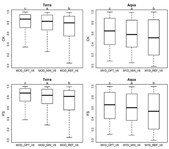
Figure 1. Comparison of station-based accuracies (CK in upper part and FS in lower part) from the three different NDSI threshold schemes for Terra (left) and Aqua (right) based on paired t-tests. (Image by ITPCAS)
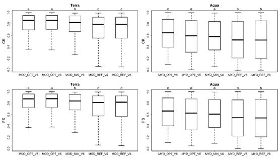
Figure 2. Comparison of station-based accuracies (CK in upper part and FS in lower part) from the five different NDSI threshold schemes of products V5 and V6 for Terra (left) and Aqua (right) based on paired t-tests. (Image by ITPCAS)
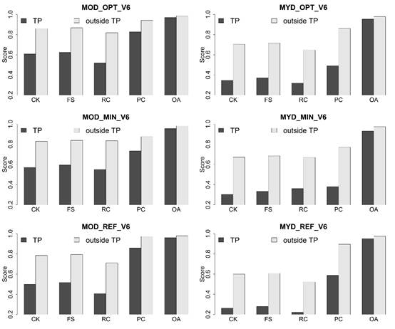
Figure 3. Comparison of validation accuracies including the CK, FS, RC, PC and OA between stations within the Tibetan Plateau (TP) and those outside the TP. (Image by ITPCAS)

86-10-68597521 (day)
86-10-68597289 (night)

86-10-68511095 (day)
86-10-68512458 (night)

cas_en@cas.cn

52 Sanlihe Rd., Xicheng District,
Beijing, China (100864)
Copyright © 2002 - Chinese Academy of Sciences


