The CAS-TWAS Centre of Excellence on Space Technology for Disaster Mitigation (CAS-TWAS SDIM), which is hosted by the CAS Institute of Remote Sensing and Digital Earth (RADI), was formally established in 2013. It aims at demonstrating cooperative research, providing application training, and offering technology transfer, team development, strategic studies, and advisory services to other developing countries for advancing their space technologies for disaster mitigation. It strives to upgrade their comprehensive capacity in using space technology to reduce disaster risks through a multi-channel international partnership.
The Centre started a cooperative research project on space technology for disaster mitigation in Asia soon after its establishment to meet scientific needs for coping with frequent natural disasters with heavy economic losses in the countries along the route of the "the Silk Road Economic Belt and the 21st-Century Maritime Silk Road (Belt and Road, B&R) " initiative. Since then the Centre has conducted 11 joint research projects with researchers from seven other developing countries (including Thailand, Mongolia, and Indonesia), covering such ?elds as ?oods, droughts, and earthquakes.
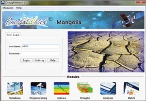
Through international partnerships, RADI’s technological achievements (such as DroughtWatch, the SatSee System, a system for modeling the outbreak risks of infectious diseases in flood zones, and a spatial information survey system in drought-prone regions) were transferred to developing countries such as Mongolia and Thailand. At present, relevant systems and products have been used in Mongolia’s National Remote Sensing Centre, the Thailand Geo-Informatics and Space Technology Development Agency, and the Kyrgyzstan Ministry of Agriculture.
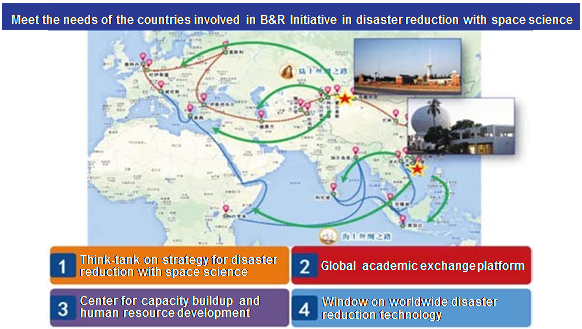
SDIM aims at strengthening ties with countries involved in the “Belt and Road” Initiative.
Over the past two years, by extending diversified cooperation networks, the Centre has steadily developed an information-sharing platform integrating data from international organizations, academia, and governmental departments in developing countries. By drawing on the wisdom of international think-tanks and the experience and lessons of advanced countries, it offers support to developing countries in their capacity building and scientific research, providing effective solutions to their problems of disaster mitigation, rescue, and recovery. So far, it has formed partnerships with more than 10 international organizations and developing countries such as the United Nations International Strategy for Disaster Reduction (UNISDR), the United Nations Platform for Space-based Information for Disaster Management and Emergency Response (UN-SPIDER), the Integrated Research on Disaster Risk Program (IRDR), the Group on Earth Observations (GEO), Mongolia’s Disaster Reduction Centre, and Sri Lanka’s Disaster Reduction Management Centre. In 2014, the Centre signed an MoU with VITO in Belgium to carry out technological cooperation with developing countries by using expertise enjoyed by the research organization.
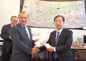
By joining hands with international partners, the Centre has carried out the task of producing a report on the research and development of space technology for disaster mitigation in developing countries. In 2014, the United Nation’s Special Representative for Disaster Risk Reduction and the head of UNISDR, Margareta Wahlstr?m, visited the Centre. The two sides decided to co-establish an international cooperative network through the UNISDR Office in Bangkok to systematically analyze the research progress and new research achievements in space technology for disaster mitigation in Asian countries, limitations of their technological development capacities, and differences and gaps between them and advanced countries. A science report will be published to offer consultancy services and support to decision-makers in these countries. So far, a framework for S&T reports on space technology for disaster mitigation in Asia--Paci?c developing countries has been completed.
An interface from the DroughtWatch system tailored for Mongolia.
The year 2015 is the starting point for a new framework of global disaster reduction. The Centre has actively taken part in the preparation of a world framework for disaster risk reduction. In March 2015, the Third UN World Conference on Disaster Risk Reduction (WCDRR) was held in Sendai, Japan, attracting the participation of over 25 heads of state, vice presidents, and heads of government. A total of 6,500 delegates from 187 countries attended the intergovernmental and multi-stakeholder events. UN Secretary General Ban Ki- moon addressed the opening ceremony. The Centre co-hosted the working session “Earth Observations and High Technology to Reduce Risks” with other international partners such as the UN Office for Outer Space Affairs (UNOOSA), Group on Earth Observations (GEO), Committee on Earth Observation Satellites (CEOS), European Space Agency (ESA), German Aerospace Centre (DLR), Food and Agriculture Organization of the United Nations (FAO), and UN Committee of Experts on Global Geospatial Information Management (UN-GGIM). A whitepaper titled Earth Observations in Support of National Strategies for Disaster-risk Management was co-released, providing an impetus for the creation of a framework for a global space-based technology plan for disaster risk mitigation under the Sendai Framework for Disaster Risk Reduction: 2015-2030. It will serve strategic planning in countries around the world.
The "Belt and Road" initiative is China’s new move to strengthen its ties in the global economy. In 2015, focusing on the needs of disaster reduction in developing countries along the route, the Centre will continuously take advantage of its expertise in international cooperation in a variety of activities, ranging from space technology development for disaster reduction, to technology transfer and talent training, making more contributions to the advancement of space technology for disaster mitigation in developing countries along the route and in the region. (BCAS)
A Virtual Ground Station system developed by SDIM is now in operation at Kyrgyzstan.
